


There is an important gap in the trail at the Souhegan River Valley due to the removal of the extensive steel structure that once carried the railroad across the valley. Accordingly the 'eastern section' of the trail ends at the east abutment for the trestle a short distance beyond the Adams Hill Road Crossing (Greenville). The Western section of the trail presumably begins at the west abutment of the trestle then curves south to the former Greenville Depot.
|
|
An informal bypass of this gap for 'street legal' trail users leaves the trail at the Adams Hill Road Crossing and descends sharply to Route 31. The bypass then follows Route 31 south to the next intersection, then turns west on Wilton Road which immediately crosses an old truss bridge. The Wilton Road then passes a factory and rises as it turns south unto it runs alongside the railroad bed. Trail users can then return to the railroad bed at the first opening, roughly a quarter-mile north of the former Greenville Depot.
The Webmaster did note a mountain bike trail that descends steeply to Route 31 from a point near the east abutment of the trestle. However, this trail is so steep that the Webmaster seriously expects that each user has contributed to the serious erosion of the railroad embankment adjacent to the east abutment for the trestle. Accordingly, trail conservation ethics suggest that this route be avoided until such time as a proffesionally designed mountain bike trail can be constructed for this very steep route. Note that the Webmaster suspects that an equivalent situation exists behind the factory leading to the west abutment of the trestle!
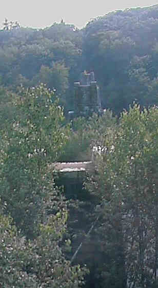
Line of granite bridge piers across Souhegan River Valley. Digital picture by Kenyon F. Karl on July 15, 1998.
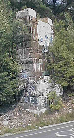
Granite bridge pier at Route 31. Digital picture by Kenyon F. Karl on July 15, 1998.
Simple public access to the east trail segment is available for 'street legal' trail users at the
following points:
Simple public access to the west trail segment is available for 'street legal' trail users at the
following points:
 Trail Parking is available at the following locations:
Adams Hill Road Crossing (east trail segment only) - This space is so limited that the webmaster suggests that this location be used only for loading and unloading of snowmobiles, horses, bicycles, and the like and to wait short periods of time for arriving trail users.
 The former Greenville Depot has been converted into a fine restaurant.
Unfortunately, the Webmaster has not have the opportunity to request the
schedule of operations for this restaurant during his late evening field check
of July 7,2000. Also missed was the opportunity to inquire whether parking,
toilets, drinking water, and the like are available to trail users.
The former Greenville Depot has been converted into a fine restaurant.
Unfortunately, the Webmaster has not have the opportunity to request the
schedule of operations for this restaurant during his late evening field check
of July 7,2000. Also missed was the opportunity to inquire whether parking,
toilets, drinking water, and the like are available to trail users.
The Webmaster likewise has not have the opportunity to drive around the area surrounding the former Greenville Depot to look for convenience stores and other facilities of obvious importance to trail users!
Click on the Mapblast Map on this page to reach an entry point to a Business Directory of the surrounding area.
Sign images are from the Manual of Traffic Signs, by Richard C. Moeur.
Updated on February 22, 2001 by Kenyon F. Karl <[email protected]> based on information collected during quick visits to the trail on July 15, 1998 and July 7, 2000. Unintentional errors are likely!
