


|
|
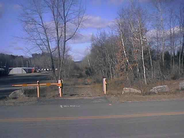
Looking north from Depot St in Boscawen. Digital photograph by Kenyon F. Karl on December 18, 1999.
The 1984 edition of the New Hampshire Atlas and Gazetteer (Delorme) suggests that the Boscawen Station was located just north of the Depot Street crossing.
The railroad ties are still in place in the heavy layer of crushed rock ballast south of the Depot Street crossing. The ties have been removed north of the crossing, but the railroad bed still contains a heavy layer of crushed rock ballast. Note that the ties are still in place south of the Depot Street crossing!
Trail access is available at the following points:
Depot St (Boscawen)
Behind Dunkin Donuts (via steep woods road)
From the Veterans Cemetery (north of Boscawen) via an unmarked farm road in the southern half of the grounds.
Information about the south end of the rail-trail has been relocated to the page that contains information about the nearby Hannah Duston Memorial.
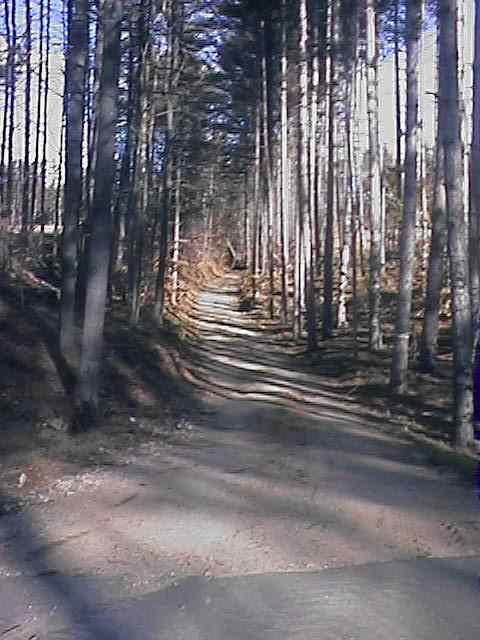
Looking east along the farm road connecting the Veterans Cemetery to the Rail-trail. Digital photograph by Kenyon F. Karl on December 18, 1999.
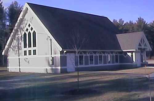
The Chapel at the Veterans Cemetery. Digital photograph by Kenyon F. Karl on December 18, 1999.
 Note that the abandoned
highway bridge across the river near the Boscawen
Depot is fenced off with signs indicating that it is
closed to all trail users due to its extremely unsafe condition!
Note that the abandoned
highway bridge across the river near the Boscawen
Depot is fenced off with signs indicating that it is
closed to all trail users due to its extremely unsafe condition!


 The Boscawen Town Park is located adjacent to the Depot Street crossing of the
rail-trail. The parking area is limited in
size and may be full during baseball games! Note that the baseball dugouts offers emergency shelter from
inclement weather except during baseball games.
The Boscawen Town Park is located adjacent to the Depot Street crossing of the
rail-trail. The parking area is limited in
size and may be full during baseball games! Note that the baseball dugouts offers emergency shelter from
inclement weather except during baseball games.


 A large convenience store (with gasoline) is located just west of the Depot Street trail crossing on King
Street (Route 3 & 4). The store offers hot coffee, cold beverages, and other
refreshments as well as limited groceries. The store is normally open 24 hours
per day, but its hours were temporarily reduced to 5am to Midnight when checked
on December 18, 1999 due to persistent staff shortages. The telephone is outside and is
thus available at all times. Toilets and water are available whenever
the store is open.
A large convenience store (with gasoline) is located just west of the Depot Street trail crossing on King
Street (Route 3 & 4). The store offers hot coffee, cold beverages, and other
refreshments as well as limited groceries. The store is normally open 24 hours
per day, but its hours were temporarily reduced to 5am to Midnight when checked
on December 18, 1999 due to persistent staff shortages. The telephone is outside and is
thus available at all times. Toilets and water are available whenever
the store is open.
 An Italian restaurant is located across from the King Street (Routes 3 & 4) end of Depot Street. Toilets and water are presumably available
upon request in the restaurant when it is open.
An Italian restaurant is located across from the King Street (Routes 3 & 4) end of Depot Street. Toilets and water are presumably available
upon request in the restaurant when it is open.
 Two motels were noted at the King Street (Routes 3 & 4) end of Depot Street.
 The Library is located on King Street (Routes 3 & 4) about a quarter mile
north of Depot St.
The Library is located on King Street (Routes 3 & 4) about a quarter mile
north of Depot St.

 The Post Office and the Historical Society are adjacent to each other a short
distance before the library. Note that the Post Office is only open in the
afternoon (6 days/week).
The Post Office and the Historical Society are adjacent to each other a short
distance before the library. Note that the Post Office is only open in the
afternoon (6 days/week).
The Veterans Cemetery
can be reached from an unmarked farm road that crosses about midway between
Boscawen and Gerrish Stations then rises through a ravine between two sections
of the Cemetery
grounds. After crossing a cemetery road, the farm road exits though the southern
entrance of the Cemetery grounds. A restaurant and a small motel are located across Route 3
a short distance north of that entrance.
 The
Senior
Transit Service of Concord
Area Transit serves the entire town of Boscawen on a Demand
Responsive Basis on Mondays Only. Riders must call in advance during
business hours to negotiate a mutually convenient pickup & dropoff times and
places. This bus does not accommodate bicycles!
The
Senior
Transit Service of Concord
Area Transit serves the entire town of Boscawen on a Demand
Responsive Basis on Mondays Only. Riders must call in advance during
business hours to negotiate a mutually convenient pickup & dropoff times and
places. This bus does not accommodate bicycles!
 US Route 4 at the west end of Depot St. is a NH-DOT Bike
Route. Note that the bike route follows Route 4 through Salisbury
to Andover and Potter Place while the Rail-trail takes a somewhat longer route via Franklin and East
Andover roughly parallel to Routes 3 & 11.
US Route 4 at the west end of Depot St. is a NH-DOT Bike
Route. Note that the bike route follows Route 4 through Salisbury
to Andover and Potter Place while the Rail-trail takes a somewhat longer route via Franklin and East
Andover roughly parallel to Routes 3 & 11.
Listed on the
National Register
of Historic Places: Any Mapblast Map on this Web Site is a link to the Mapblast Web Site which in turn leads to a Business Directory of the surrounding area.
