


|
|
![]() Brought to you by MapBlast! (Click on map to navigate)
Brought to you by MapBlast! (Click on map to navigate)
![]() USGS
Topographic map of Enfield
USGS
Topographic map of Enfield
This location was confirmed by the visible remains of the passenger platform.
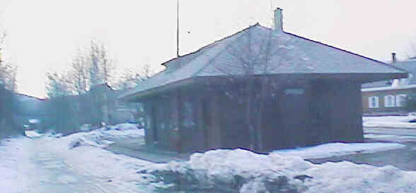
Former Enfield Depot. Digital picture by Kenyon F. Karl on March 4, 1998.
The Enfield Depot still stands, although it is currently owned by the town and used as a garage and meeting space by the town ambulance corps. The trail runs to the left (south) of this building.
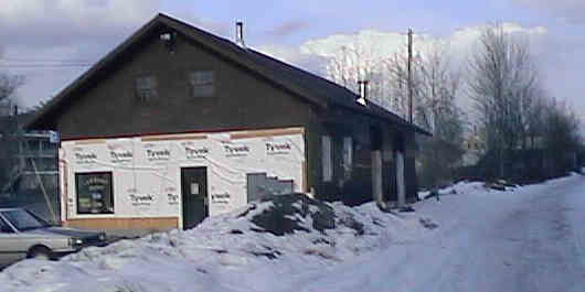
Former Enfield Freight House. Digital picture by Kenyon F. Karl on March 4, 1998.
The former Enfield Freight House has recently been repositioned on a new foundation and has been totally remodeled to serve as a laundromat and potential office/retail space. The trail runs behind (south) of this building.
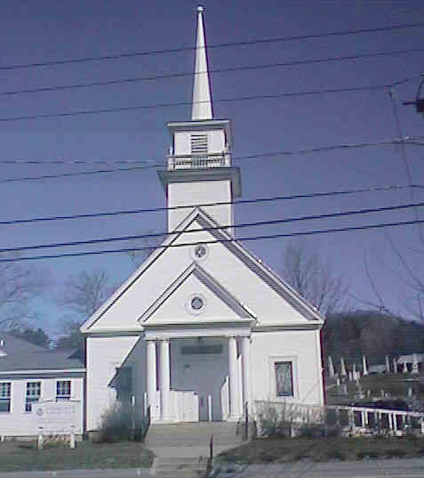
The Community Lutheran Church is easily visible from the trail. Digital picture by Kenyon F. Karl on April 30, 1999.
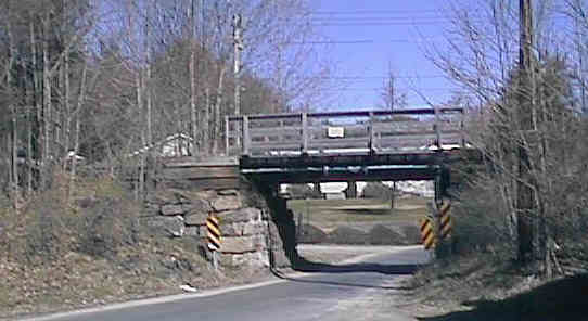
Low clearance underpass at the west end of Main Street. Digital picture by Kenyon F. Karl on April 30, 1999.
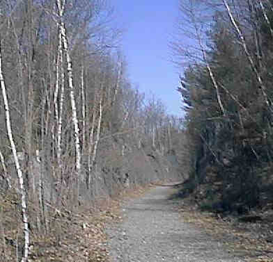
Rock cut adjacent to Mascoma Lake west of Enfield village. Digital picture by Kenyon F. Karl on April 30, 1999.
Simple trail access is available at the following points.
 The Advance
Transit Blue Route to Canaan stops on signal
anywhere along Route 4 (the thick green line on the preceding map).
Note that all Advance Transit busses have bike racks! The bus is easily
accessible at the following trail exits:
The Advance
Transit Blue Route to Canaan stops on signal
anywhere along Route 4 (the thick green line on the preceding map).
Note that all Advance Transit busses have bike racks! The bus is easily
accessible at the following trail exits:
 US Route 4 is a Statewide
Bicycle Route that roughly parallels the Rail-trail between Danbury and Lebanon.
Note however that this route detours from Huse Park west to Route 4A via Main
St., the Shaker Bridge, and Route 4A. Each of the following trail access points thus forms a short connecting link to
the Bike Route.
US Route 4 is a Statewide
Bicycle Route that roughly parallels the Rail-trail between Danbury and Lebanon.
Note however that this route detours from Huse Park west to Route 4A via Main
St., the Shaker Bridge, and Route 4A. Each of the following trail access points thus forms a short connecting link to
the Bike Route.
Note that a second Statewide
Bicycle Route runs southeast via 4A from the west end of the Shaker
Bridge to Route 11 near Potter Place Station.


 Chemical toilets, a playground, and sheltered picnic tables are
located at Huse Park at the corner of Main
Street and Route 4, open to the public on a daily basis from 6am
to 10pm daily. The park is reachable from the former Enfield
Depot by walking west along Depot St. turning north to
cross the river, and then walking northeast along Main Street. It
is also reachable from the former Freight House
by walking northeast along Main St.
Chemical toilets, a playground, and sheltered picnic tables are
located at Huse Park at the corner of Main
Street and Route 4, open to the public on a daily basis from 6am
to 10pm daily. The park is reachable from the former Enfield
Depot by walking west along Depot St. turning north to
cross the river, and then walking northeast along Main Street. It
is also reachable from the former Freight House
by walking northeast along Main St.


 The Library and Police
Station are located next to each other a short distance south of Huse
Park, with the public telephone located on the driveway between the two
buildings. The Post Office is located across Route 4 a short distance north of the Park.
The Library and Police
Station are located next to each other a short distance south of Huse
Park, with the public telephone located on the driveway between the two
buildings. The Post Office is located across Route 4 a short distance north of the Park.


 Limited food service, limited groceries, and gasoline are
available at the Enfield AG Store located across Main Street from
the former Enfield Freight House. Toilets and water are
presumably available upon request. Store hours are: Monday-Friday 6 am to 10 pm,
Sat & Sun 8 am to 10 pm.
Limited food service, limited groceries, and gasoline are
available at the Enfield AG Store located across Main Street from
the former Enfield Freight House. Toilets and water are
presumably available upon request. Store hours are: Monday-Friday 6 am to 10 pm,
Sat & Sun 8 am to 10 pm.
 The former Enfield
Freight
House houses a laundromat.
The former Enfield
Freight
House houses a laundromat.
Janet's Roadside Cafe is reachable by
leaving the trail at a ramp just east of the Pillsbury Street
Overpass and turning north to cross the river, then turning west
on Baltic Street. A sidewalk and footbridge across the brook also
allows safe walking east from Huse Park. The
restaurant is open daily for breakfast and lunch (6-2 M-F, 6-3
Sat, 7-2 Sun) and for dinner (4-8) on Thu-Fri-Sat nights. Toilets
and water are presumably available upon request whenever the restaurant is open.
 A town swimming
area is located at the southwest end of the Shaker Bridge, on the way to the Shaker Historic District
& Museum. Note that trail users should leave the trail at the
end of Bridge street then cross the bridge to reach the swimming area.
A town swimming
area is located at the southwest end of the Shaker Bridge, on the way to the Shaker Historic District
& Museum. Note that trail users should leave the trail at the
end of Bridge street then cross the bridge to reach the swimming area.
 The Shaker Bridge
Motel is located next to the low clearance underpass at the west end of Main St.
An inn is located on the grounds of the Enfield
Shaker Museum, and a Bed &
Breakfast is adjacent to the Museum.
The Shaker Bridge
Motel is located next to the low clearance underpass at the west end of Main St.
An inn is located on the grounds of the Enfield
Shaker Museum, and a Bed &
Breakfast is adjacent to the Museum.
Fine dining is
available at the inn on the grounds of the Enfield
Shaker Museum, and a cafeteria is located in the nearby La
Salette Shrine.
 Listed on the National Register of
Historic Places:
Listed on the National Register of
Historic Places:|
|
Sign images are from the Manual of Traffic Signs by Richard C. Moeur.
Updated on February 14, 2001 by Kenyon F.
Karl <[email protected]>.
Unintentional errors are likely!
