


|
|
The location of the former station was confirmed by the visible remains of the passenger platform, just west of the Spencer Street Crossing.
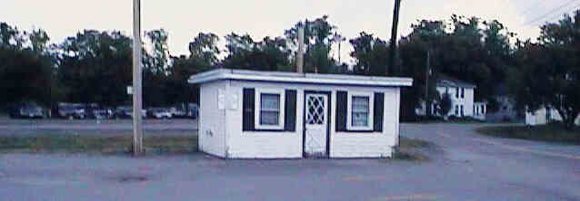
Small building on remains of passenger platform. Digital picture by Kenyon F. Karl on August 31, 1997.
The trail currently ends at the east side of the Spencer Street Crossing, across from a small white building at the east end of the Senior Center Parking Lot.
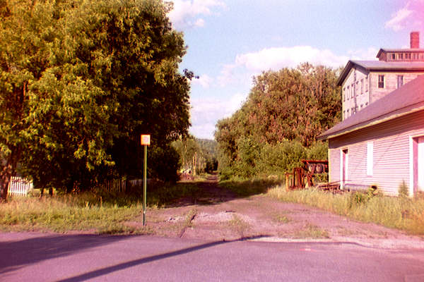
East from Spencer St. Crossing. Kodacolor photo by Kenyon F. Karl taken on July 6, 1997, scanned during photo processing using the Konica Picture Show option.
This view looks east across the Spencer Street crossing at the current western end of the trail at the Spencer Street crossing near downtown Lebanon. The site of the Lebanon Depot is just west of this crossing. The building on the right must have been the Lebanon Freight House.
![]() State ownership of the right of way continues
west of the current end of the trail in downtown Lebanon for
about two miles. This roadbed is potentially available for a
future extension of either the railroad or the rail-trail. However, this portion of the railroad is not
maintained in any way and is thus potentially hazardous for all
trail users! Note also that
the final 2.75 miles of railroad to the State Line near White River Junction VT has recently been
purchased by the State and leased to the Claremont-Concord Railroad. Although the tracks
may appear to be dormant, railroad freight service could resume without
notice!
State ownership of the right of way continues
west of the current end of the trail in downtown Lebanon for
about two miles. This roadbed is potentially available for a
future extension of either the railroad or the rail-trail. However, this portion of the railroad is not
maintained in any way and is thus potentially hazardous for all
trail users! Note also that
the final 2.75 miles of railroad to the State Line near White River Junction VT has recently been
purchased by the State and leased to the Claremont-Concord Railroad. Although the tracks
may appear to be dormant, railroad freight service could resume without
notice!
Simple trail access is available
at the following points:
at the Spencer Street Crossing (site of Lebanon Depot).
at the back of the Lebanon Junior High School.
to the end some minor streets off of Spencer St.
At crossing of Bank Street Extension
From the west end of the bridge near the pumping station around the west side of the storage buildings to Bank St & Heater Rd.
Riverside Drive Crossing.
 The Advance
Transit bus stops on Flynn St near Campbell St. (closest to the Spencer St
Crossing)) with another stop near the east end of the downtown mall. Their Blue Route provides frequent
FREE service from these particular bus stops to Dartmouth Hitchcock Medical Center
and downtown Hanover. Note also that selected trips of the Blue
Route (not free) run east via Route 4 to Canaan, roughly paralleling the
rail-trail, stopping on signal at any convenient and
safe place east of the Lebanon Junior High School. Their Red Route
(not free) provides transportation to West Lebanon with a
connecting Orange Route bus to White River Junction VT.
Note that all
Advance Transit busses on weekdays only but have bike racks!
The Advance
Transit bus stops on Flynn St near Campbell St. (closest to the Spencer St
Crossing)) with another stop near the east end of the downtown mall. Their Blue Route provides frequent
FREE service from these particular bus stops to Dartmouth Hitchcock Medical Center
and downtown Hanover. Note also that selected trips of the Blue
Route (not free) run east via Route 4 to Canaan, roughly paralleling the
rail-trail, stopping on signal at any convenient and
safe place east of the Lebanon Junior High School. Their Red Route
(not free) provides transportation to West Lebanon with a
connecting Orange Route bus to White River Junction VT.
Note that all
Advance Transit busses on weekdays only but have bike racks!
The following are additional trail exits to the bus route via Rte. 4 to Enfield & Canaan (not free):
 US Route 4 is a Statewide
Bicycle Route that roughly parallels the Rail-trail between Danbury and
Lebanon except for a detour east via Riverside Drive, Bank Street Extension and
Heater Road to Hanover Street (Lebanon High School). A second bike route leaves
the Common running south on Route 120. A third bike route leaves the common on
Hanover Street crosses I-89 on a pedestrian bridge and continues north to
Hanover via Mt. Support Road. The following trail exits connect to the bike
route system:
US Route 4 is a Statewide
Bicycle Route that roughly parallels the Rail-trail between Danbury and
Lebanon except for a detour east via Riverside Drive, Bank Street Extension and
Heater Road to Hanover Street (Lebanon High School). A second bike route leaves
the Common running south on Route 120. A third bike route leaves the common on
Hanover Street crosses I-89 on a pedestrian bridge and continues north to
Hanover via Mt. Support Road. The following trail exits connect to the bike
route system:


 The Amtrak station, the Vermont
Transit/Greyhound
bus
station, and the Hotel Coolidge
(hotel & hostel) are
located in White River Junction VT. Note that Amtrak's daily Vermonter runs
between St. Albans VT and Washington DC and features a baggage car with bike
racks. This train will also transport bikes in boxes to all other Amtrak
stations that handle checked baggage. Vermont Transit (Greyhound) will transport
bikes in boxes as passenger baggage. Advance
Transit Red Route with connecting Orange Route provides a connecting bus
service on weekdays only, and US Route
4 is a Statewide
Bicycle Route from the Lebanon Common to the
State Line in West Lebanon.
The Amtrak station, the Vermont
Transit/Greyhound
bus
station, and the Hotel Coolidge
(hotel & hostel) are
located in White River Junction VT. Note that Amtrak's daily Vermonter runs
between St. Albans VT and Washington DC and features a baggage car with bike
racks. This train will also transport bikes in boxes to all other Amtrak
stations that handle checked baggage. Vermont Transit (Greyhound) will transport
bikes in boxes as passenger baggage. Advance
Transit Red Route with connecting Orange Route provides a connecting bus
service on weekdays only, and US Route
4 is a Statewide
Bicycle Route from the Lebanon Common to the
State Line in West Lebanon.
 All-day and
overnight parking is available in the lower parking lot (north of
the abandoned railroad track) north of the mall and a short walk
directly west of the end of the trail via Taylor Street.
All-day and
overnight parking is available in the lower parking lot (north of
the abandoned railroad track) north of the mall and a short walk
directly west of the end of the trail via Taylor Street.


 A picnic table and
playground are located just west of the Carter-Witherell
Center. Public toilets and water are available upon request inside the Carter-Witherell
Center (large red brick building adjacent to the Spencer Street crossing) during scheduled building hours:
A picnic table and
playground are located just west of the Carter-Witherell
Center. Public toilets and water are available upon request inside the Carter-Witherell
Center (large red brick building adjacent to the Spencer Street crossing) during scheduled building hours:
|
|
 Public toilets and water are available at City Hall during business hours (Mon-Fri 9 am to 5 pm).
A public phone is outside on the front wall of the building near its southeast
corner. This
historic building faces the Common on Park Street.
Public toilets and water are available at City Hall during business hours (Mon-Fri 9 am to 5 pm).
A public phone is outside on the front wall of the building near its southeast
corner. This
historic building faces the Common on Park Street.

 Restaurants and stores
of various kinds are located in and around the Mall that runs
west of the bus stop. Toilets and water are presumably available
upon request at each restaurant. The mall can also be entered
from a ramp to a pedestrian overpass of the abandoned railroad
track at the east end of the all-day parking area. Bicycle
Repairs are available during business hours at The Sport Exchange,
located on the mall near the bus stop.
Restaurants and stores
of various kinds are located in and around the Mall that runs
west of the bus stop. Toilets and water are presumably available
upon request at each restaurant. The mall can also be entered
from a ramp to a pedestrian overpass of the abandoned railroad
track at the east end of the all-day parking area. Bicycle
Repairs are available during business hours at The Sport Exchange,
located on the mall near the bus stop.
 The abandoned railroad tunnel that runs
under the mall could serve as an emergency trail shelter.
The abandoned railroad tunnel that runs
under the mall could serve as an emergency trail shelter.
 A large grocery store is located south of the mall and across the
main street, next to the fire station. Some 'ready to eat' food is also
available on a carryout basis. Toilets and water are presumably available in the
store upon
request.
A large grocery store is located south of the mall and across the
main street, next to the fire station. Some 'ready to eat' food is also
available on a carryout basis. Toilets and water are presumably available in the
store upon
request.

 The library
and post office are adjacent to each other at the southeast corner of the
Common. Public telephones are available at the street between the two
buildings.
The library
and post office are adjacent to each other at the southeast corner of the
Common. Public telephones are available at the street between the two
buildings.
 An information booth is at the
east edge of the park. It is open limited hours during
the summer months only. The elevated bandstand on the back side of the
information booth could serve as an emergency trail shelter if not otherwise in use.
An information booth is at the
east edge of the park. It is open limited hours during
the summer months only. The elevated bandstand on the back side of the
information booth could serve as an emergency trail shelter if not otherwise in use.
|
|
 Goodwin
Park (City of
Lebanon Recreation Department) is located at the site of Storrs
Hill Ski Area on Spring Street. It offers hiking and swimming (at
your own risk). A detailed map of the park is available from the agency office
in City Hall.
Goodwin
Park (City of
Lebanon Recreation Department) is located at the site of Storrs
Hill Ski Area on Spring Street. It offers hiking and swimming (at
your own risk). A detailed map of the park is available from the agency office
in City Hall.
 Fort Lou Truck Stop
contains a restaurant and convenience store that is open 24 hours
7 days. Showers are available downstairs off of the truckers lounge. Its primary convenience is for motorists that will begin or end their
usage of the trail at the Lebanon Trailhead when the in-town restaurants are closed. Automobile drivers should
follow the river west from the parking lot then turning north out
of the downtown shopping plaza, following Route 120 across Route
I-89, then turning right at Heater Road a quarter-mile north of
the interchange. Note that the NH-DOT Bike Route on Heater Road from the Bridge
near Pumping Station (below) offers the best route for bicycle tourists and
hikers.
Fort Lou Truck Stop
contains a restaurant and convenience store that is open 24 hours
7 days. Showers are available downstairs off of the truckers lounge. Its primary convenience is for motorists that will begin or end their
usage of the trail at the Lebanon Trailhead when the in-town restaurants are closed. Automobile drivers should
follow the river west from the parking lot then turning north out
of the downtown shopping plaza, following Route 120 across Route
I-89, then turning right at Heater Road a quarter-mile north of
the interchange. Note that the NH-DOT Bike Route on Heater Road from the Bridge
near Pumping Station (below) offers the best route for bicycle tourists and
hikers.
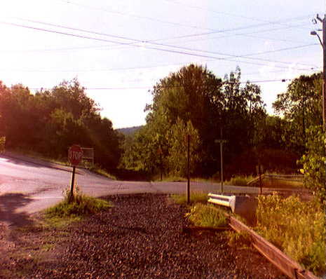
Looking West across Bank St. Ext. Crossing. Kodacolor photo by Kenyon F. Karl on July 6, 1997, scanned using the Konica Picture Show photo processing option.
An outdoor chemical toilet is currently located at the east end
of the Pat Walsh Park, just across the highway river bridge from
the crossing. This toilet is available on a 24 hour/day basis.
Refreshments, ice cream and limited groceries are available at the Riverside Store
located just beyond Pat Walsh Park. A public phone is located on the front of
the building.
 The Lebanon Memorial Pool (City of
Lebanon Recreation Department) is located on Pumping
Station Road in Lebanon. It is a 50 meter pool with two 1 meter
diving boards, a depth of 3 to 10 feet and a small wading pool
for younger children. The pool will be open 7 days a week between June 16 and
August 21, 1999 dependent upon weather conditions.
The Lebanon Memorial Pool (City of
Lebanon Recreation Department) is located on Pumping
Station Road in Lebanon. It is a 50 meter pool with two 1 meter
diving boards, a depth of 3 to 10 feet and a small wading pool
for younger children. The pool will be open 7 days a week between June 16 and
August 21, 1999 dependent upon weather conditions.
Click on the map to browse!
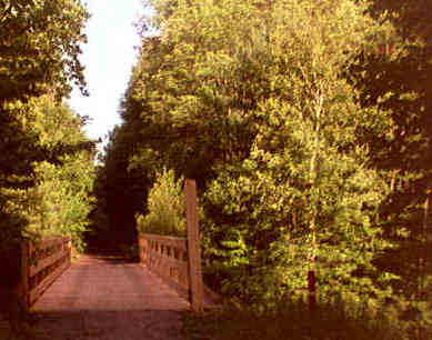
Bridge near Pumping Station. Kodacolor photo by Kenyon F. Karl on July 6, 1997, scanned using the Konica Picture Show photo processing option.
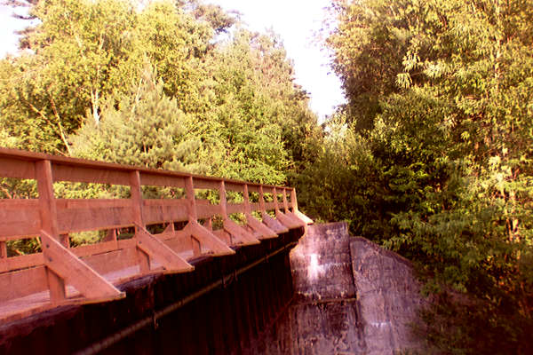
Railing of Bridge near Pumping Station. Kodacolor photo by Kenyon F. Karl on July 6, 1997, scanned using the Konica Picture Show photo processing option.
Note that the Lebanon Bicycle & Pedestrian Committee has started the construction of a new trail across city-owned land to connect the east end of this bridge to the Municipal Pool. A rough trail did exist in 1997 but was severed in 1998 by the construction of a new fence near the pool. Until this trail is complete, trail users must use Pumping Station Road to reach the pool.
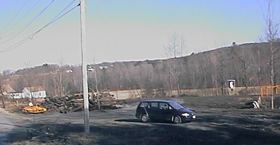
Riverside Drive Parking Area. Digital picture by Kenyon F. Karl on April 12, 1999.
|
|
The Twin States Trail Busters have built a small
parking area at the Riverside Drive Crossing. This parking area is suitable for
snowmobile and horse trailers.
 Packard
Hill Covered Bridge #67 is located on Riverside Drive about 0.2 mile west of the crossing. Note that Riverside Drive
is adjacent to the trail for most of that distance.
Packard
Hill Covered Bridge #67 is located on Riverside Drive about 0.2 mile west of the crossing. Note that Riverside Drive
is adjacent to the trail for most of that distance.
The
Riverside Grill (seasonal) is located on Riverside Drive about 0.3 mile east of the crossing, just beyond the Interstate Highway
underpass. Toilets and water are presumably available upon request when the
restaurant is open. A public phone is located on the front wall of the building and is thus available at all times.
Listed on the
National Register
of Historic Places:Colburn Park Historic District N., S., E., and W. Park Sts., 3 Campbell St., 1 School St., 1 Bank St., and 9--10 Lebanon Mall Lebanon
City
Guide to Historic LandmarksThis page of the City of Lebanon Web Site provides a brief history of each historic landmark designated by the City's Historic Commission. Pictures are provided for some of the historic sites.
Lebanon Historical SocietyThe Lebanon Historical Society has more information as well as publications for sale about the history of Lebanon.
Boston & Maine Railroad Locomotive 494The historic B&M RR locomotive is on display adjacent to the White River Junction railroad station. The Advance Transit Red route & connecting Orange Route bus runs on weekdays between the downtown Lebanon bus stops to a bus stop at the nearby Coolidge Hotel.
Sign images are from the Manual of Traffic Signs by Richard C. Moeur.
Updated on March 20, 2002 by Kenyon F.
Karl <[email protected]>.
Unintentional errors are likely!
