


Click on the map to browse!
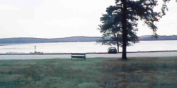
Lake Massabesic from picnic area. Digital picture by Kenyon F. Karl on August 5, 1998.
The State-owned Rail-trail apparently begins at Lake Shore Road, about a half-mile west of Massabesic and runs east from that point to Rockingham Junction.
Note that a trail continues west on the rail bed from Lake Shore Road to the I-93 embankment. The trail is narrow presumably due to lack of usage, and there are no signs to identify trail ownership or permitted uses. Note the relatively new curbstone at the west side of the Proctor road crossing is not ADA compliant.
A trail underpass does penetrates the I-93 embankment, but the trail appears to end a short distance west of that point. Note however that Interstate exit ramps run at ground level on either side of I-93 between Hanover Street and Candia Road underpasses. The pavement and the adjacent strip of grass are both wide enough so that mature 'street legal' trail users can reach either of these streets with a reasonable assurance of safety.
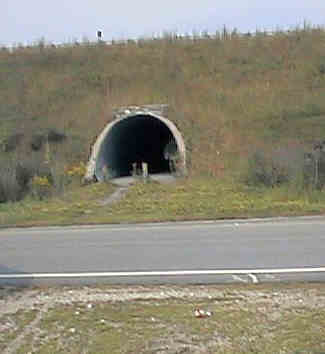
Trail culvert at I-93. Digital picture by Kenyon F. Karl on August 5, 1998.
 Manchester
Transit Authority Route #2 Lake-Hanover
(weekdays) and Route #4
- Page - Elliot - Hanover (Saturdays) serves the trail at the following
points:
Manchester
Transit Authority Route #2 Lake-Hanover
(weekdays) and Route #4
- Page - Elliot - Hanover (Saturdays) serves the trail at the following
points:
a bus stop sign on Hanover Street, a short distance north of the I-93 underpass.
a bus stop sign on Candia Road near the north end of Lake Shore Road.
a bus stop sign at the Massabesic Traffic circle, just north of the Route 28 Bypass crossing.
Note that MTA busses do not have bike racks!


 The parking and
picnic area at Lake Massabesic just south of the Route 28 bypass
crossing is open from 8 am to 8 pm only. The gates are locked at
all other times. Swimming, wading, and fires are not allowed since the lake is a public water
supply. Dumpsters are
provided for the disposition of picnic trash.
The parking and
picnic area at Lake Massabesic just south of the Route 28 bypass
crossing is open from 8 am to 8 pm only. The gates are locked at
all other times. Swimming, wading, and fires are not allowed since the lake is a public water
supply. Dumpsters are
provided for the disposition of picnic trash.

 A convenience store with grill is located at the
traffic circle just north of the Route 28 bypass crossing. A gas
station is also located on the traffic circle.
A convenience store with grill is located at the
traffic circle just north of the Route 28 bypass crossing. A gas
station is also located on the traffic circle.


 A restaurant is
located adjacent to the gas station, another restaurant and a
pizza parlor are just west of the traffic circle on Candia Road.
Toilets and water are presumably available upon request at the
restaurants and pizza parlor upon request during operating hours.
A restaurant is
located adjacent to the gas station, another restaurant and a
pizza parlor are just west of the traffic circle on Candia Road.
Toilets and water are presumably available upon request at the
restaurants and pizza parlor upon request during operating hours.
 One branch of the Statewide
Bicycle Route System passes through the Massabesic traffic circle
on Candia Road just north of theabout trail crossing of Rte. Bypass
28. Note that this route turns south to cross the Rail-trail at the Lake Shore
Road crossing. A second Branch of the Bike Route System continues
west on Wellington Road, about 0.4 mile north of the Bypass 28 trail Crossing.
Because of the presence of a Route 101 highway interchange, traffic on
Bypass 28 can be extremely heavy at this point.
One branch of the Statewide
Bicycle Route System passes through the Massabesic traffic circle
on Candia Road just north of theabout trail crossing of Rte. Bypass
28. Note that this route turns south to cross the Rail-trail at the Lake Shore
Road crossing. A second Branch of the Bike Route System continues
west on Wellington Road, about 0.4 mile north of the Bypass 28 trail Crossing.
Because of the presence of a Route 101 highway interchange, traffic on
Bypass 28 can be extremely heavy at this point.
Click on the map to browse!
Severance must have been the rural train stop that served the many camps along the north and northwest sides of the lake.
No trail facilities were observed in this vicinity!
A junction of the Statewide
Bicycle Route System is just north of the Route 101 underpass,
about 0.2 miles west of Severence Station.
Sign images are from the Manual of Traffic Signs, by Richard C. Moeur.
Updated on February 22, 2001 by Kenyon F.
Karl <[email protected]>.
Unintentional errors are likely!
