Miles* |
Station |
|---|---|
| 41.47 | Atlantic |
| 42.66 | Seabrook |
| 44.36 | Hampton Falls |
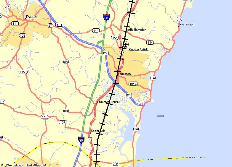
| 46.52 | Hampton |
| 48.69 | North Hampton |
| 51.40 | Breakfast Hill |
| 56.91 | Portsmouth |
* = Railroad Miles from Boston
Italic indicates points on active railroad
Dark Face = Telegraph Station in 1923
The Webmaster undertook a quick photographic tour on April 29, 2001 for the purpose of exploring the feasibility of opening the abandoned railroad bed for rail-trail use between the MBTA Commuter Rail Station at Newburyport MA to the end of the active railroad track in Hampton, NH. Photographs taken during that excursion have been segregated into groups based upon the name of the nearest historic railroad station. The station names in the preceding railroad mileage chart as well as the chart for the Border to Boston Bikeway, are links to the individual pages of photographs and field notes.
Map of Phase 1, as supplied by Krystina Deren Arrain
A Rail-with-trail route near the seacoast has been planned for the New Hampshire segment of the East Coast Greenway:
The East Coast Greenway has recently been selected as one of 15 trails for designation as a Millenium Trail, which should be very helpful in focusing public attention on all of the component trail projects.
Trail planners must note however that Guilford Transportation Industries still owns and operates the railroad line between Hampton and Portsmouth and thence to their main line at Rockingham Junction, thus relinquishment of any part of this right of way for either Rail-trail or Rail-with-trail purposes by the current railroad management is unlikely as long as this freight service is considered to be profitable.
In any event, trail planners must pay attention to a recent proposal to study the potential for rail commuter service between Newburyport and Portsmouth as a further extension of the recently restored rail commuter service to Newburyport. Reconstruction of the railroad implies that a successful Rail-trail would be converted into a Rail-with-trail or the bikeway would have to be relocated elsewhere in the region, if not abandoned.
| Docket | Line | From | MP | To | MP | Year | RR | Miles |
|---|---|---|---|---|---|---|---|---|
| AB-32-57X | Hampton | Hampton | 42.70 | Seabrook | 46.00 | 1997 | B&M | 3.30 |
From abandonment notices published in the Federal Register (1994-1998).
A brief history of the Eastern Line is published in Section #58 in The Rail Lines of Southern New England by Ronald Dale Karr, published by Branch Line Press in 1995.
| Name | Route | Number | Description | Years | Cost $(M) |
|---|---|---|---|---|---|
| Statewide | Hampton Br. RR | 12630 | Acquisition of 4.5 miles of abandoned corridor from Mass S/L to Hampton for recreational purposes [96-71TE] | R1999 | .602 |
Years: R= Right-of-way acquisition, C=Construction
From the Ten Year Transportation Improvement Program 1999-2008 prepared by the NH Department of Transportation and submitted to the Legislature by the Governor in December of 1997.DEPARTMENT OF TRANSPORTATION - Authorized to enter into a Purchase and Sale Agreement with the Boston and Maine Corporation for a total price not to exceed $1,430,000 to acquire portions of the abandoned Portsmouth and Hampton Branch Railroad Lines.
| Project Name | Year | City | County | Federal $ | Local $ | Total $ |
|---|---|---|---|---|---|---|
| Acq. Hampton Br. RR corridor | 1998 | STATEWIDE | N/A | $217,600 | $54,400 | $272,000 |
This list is drawn on April 8, 2000 from a database maintained by the National Transportation Enhancements Clearinghouse. Direct questions to NTEC at 1-888-388-NTEC or by email to [email protected].
Sign images are from the Manual of Traffic Signs by Richard C. Moeur.
Updated on May 02, 2001 by Kenyon F.
Karl <[email protected]>.
Unintentional errors are likely!

Add Language Translation to your browser from the Babel Fish Tool page from AltaVista: