
|
|
![]() USGS
Topographic map of Horse Meadow
USGS
Topographic map of Horse Meadow
Horse Meadow must have been located near the Grafton County Farm in North Haverhill, which has since evolved into the expansive Grafton County Complex. A railroad underpass just north of the County Complex was obviously eliminated in the course of a highway improvement project. Unfortunately, this highway project did not anticipate a trail on the old railroad bed.
A trailer park uses the railroad bed as an access road to the trailer lots just south of the Grafton County Complex.
Note that the railroad used its own very obvious embankment from the Grafton County Complex north to Route 135, with signs of regular ATV usage. The right of way is easy to find north of Route 135 until it approaches Route 302 in Woodsville. At that point the roadbed is obscured if not blocked by street and highway reconstruction and commercial buildings near 'The Railyard'. Accordingly, the trail may end behind these buildings. However, adjacent public streets can be used as a bypass to the Ames parking lot.
The roadbed of the Blackmount Branch resumes a short distance north of the Ames parking lot, running along the edge of the street until it meets the Woodsville - Littleton Rail-trail. The Woodsville Depot is perhaps a half-mile north of this point. Information about the downtown area will be found on the Woodsville page thereof.
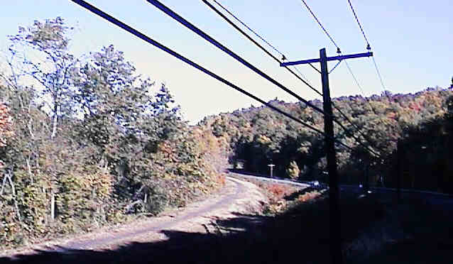
Railroad embankment just north of Grafton County Complex. Digital photograph by Kenyon F. Karl on October 8, 1997.
Each location map on this Web Site is a link to a map on the Mapblast Web Site which in turn contains a link to a Business Directory of the surrounding area.


 A sandwich shop and a gasoline station are part of the cluster of
commercial buildings at the north end of the Blackmount Trail in
Woodsville. Toilets and water are presumably
available at either or both places.
A sandwich shop and a gasoline station are part of the cluster of
commercial buildings at the north end of the Blackmount Trail in
Woodsville. Toilets and water are presumably
available at either or both places.
More trail facilities are listed on the Woodsville section of the Woodsville - Littleton Rail-trail.
Sign images are from the Manual of Traffic Signs by Richard C. Moeur.
Updated on February 27, 2001 by Kenyon F.
Karl <[email protected]>.
Unintentional errors are likely!
