|
|
|
|
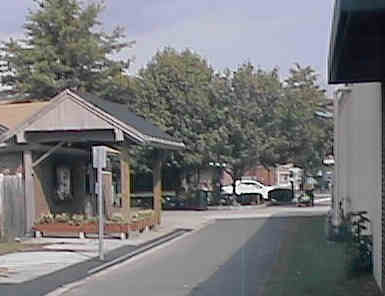
This shelter is a permanent reminder that the Keene railroad station once occupied the site. Digital photograph by Kenyon F. Karl on September 12, 1998.
The modern Keene Transportation Center occupies the site of the Keene Railroad Station near the intersection of Main Street and Gilbo Avenue. A short remnant of the old railroad platform shelter still stands next to the newsstand on Main Street, and the granite curb stones along the north edge of the path once served as the trackside edge of the old railroad station platform.
The rail-trail owned by the City of Keene northwest of Joslin Station and east of the West Street Underpass.
The City Planning Office is planning to reconstruct the rail-trail southeast of Main Street as part of its alternate transportation and recreational pathway system. Those plans may include an extension to Joslin in coordination with the NH-DOT plan to reconstruct the Keene Bypass Highway.
Pathways for Keene is responsible for fund-raising and volunteer support for these plans.


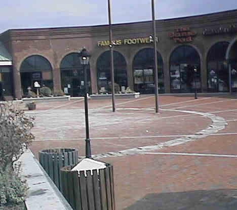
The plaza on the East side of Main St. Digital photograph by Kenyon F. Karl on September 12, 1998.
As of September 12, 1998, the old railroad bed between Route 101 near Joslin Station and downtown Keene was blocked in several different places. Note that the rail-trail information for Joslin Station suggests a suitable detour route between Joslin and Keene Stations!
The Bike Path currently begins at a parking lot just east of downtown Main Street. It then traverses a plaza, crosses Main Street then runs behind the bus station on Gilbo Ave. The trail then runs west alongside Gilbo Avenue in the approximate location of the abandoned railroad bed, passing a a parking lot and a skateboard park.
The rail-trail passes behind the Keene Bus Station. Digital photograph by Kenyon F. Karl on September 12, 1998.
A skateboard park is located adjacent to the bike trail in downtown Keene. Digital photograph by Kenyon F. Karl on September 12, 1998.
Unfortunately, the trail ends after an eighth of a mile at School Street. Trail users must then thread their way through two shopping center parking lots to reach the next section of the trail.
Note that the School Street Crossing is the appropriate place to turn south to reach beginning of the Asheulot Branch Rail-Trail.
One section of the shopping mall at School Street occupies the old railroad car shop. Digital photograph by Kenyon F. Karl on September 12, 1998.
Another section of shopping center occupies the old railroad roundhouse, and uses part of the site of the railroad turntable as a semi-circular plaza. Digital photograph by Kenyon F. Karl on September 12, 1998.
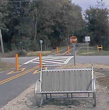
The paved bicycle path begins again at Island Avenue, and follows the railroad bed across the Asheulot River on a new trail bridge then crosses Pearl Street and continues to a fence at the edge of the Keene Bypass Highway. The path then turns abruptly north to run between the busy limited access highway and a shopping center and then terminate near the West Street underpass between a highway exit ramp and the shopping center parking lot.
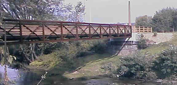
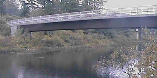
The new trail bridge across the Asheulot River. Digital photograph by Kenyon F. Karl on September 12, 1998.
Benches at Pearl Street Crossing incorporate a bicycle theme. Digital photograph by Kenyon F. Karl on September 12, 1998.
The fence at the edge of the Keene Bypass Highway. Digital photograph by Kenyon F. Karl on September 12, 1998.
The Louis Berger Group, Inc. has been selected by the New Hampshire Department of Transportation to perform highway, structural, and traffic design services for a major infrastructure project in Keene, NH. The project also includes six miles of multi-use trail construction. Generally, the trail will parallel Routes 9 and 101 and Connect into an existing trail network. The trail will serve an active constituency of snowmobilers, equestrians, cyclists and pedestrians, linking commercial centers along West Street, Winchester Street and Main Street while also providing access to the rural outlying areas and Keene State College. A trail overpass of Route 101 is also planned; this will link a KSC recreational facility to the existing trail network.
The preceding text was copied using OCR software from a marketing brochure
produced by The Louis Berger Group in May of 2001.
Unintentional errors are
likely.
 Vermont
Transit stops at the Keene Bus Station (on
the site of the former railroad station) on a daily basis with intercity bus service between
Boston, Keene, Brattleboro, and Rutland (#1990). Vermont Transit
also serves Keene on a daily basis with intercity bus service
between Springfield MA and White River Jct (#1995). Vermont
Transit handles bicycles in boxes along with other checked
baggage at Keene and other full service agency stations.
Vermont
Transit stops at the Keene Bus Station (on
the site of the former railroad station) on a daily basis with intercity bus service between
Boston, Keene, Brattleboro, and Rutland (#1990). Vermont Transit
also serves Keene on a daily basis with intercity bus service
between Springfield MA and White River Jct (#1995). Vermont
Transit handles bicycles in boxes along with other checked
baggage at Keene and other full service agency stations.
 City
Express provides city bus service within the city of Keene on
weekdays only. Note that this bus does not appear to accommodate
bicycles! This bus serves the following points near the
rail-trails:
City
Express provides city bus service within the city of Keene on
weekdays only. Note that this bus does not appear to accommodate
bicycles! This bus serves the following points near the
rail-trails:


 Public toilets, water, and public phones are available within
the Keene Bus Station whenever the building is
open (roughly 8 am to 5 pm Monday thru Saturday, and at limited
times on Sunday). A remnant of the old railroad station platform canopy behind
the bus station is usable as a shelter at all times.
Public toilets, water, and public phones are available within
the Keene Bus Station whenever the building is
open (roughly 8 am to 5 pm Monday thru Saturday, and at limited
times on Sunday). A remnant of the old railroad station platform canopy behind
the bus station is usable as a shelter at all times.
 An old-fashioned diner is located across the
street from the Keene Bus Station. Toilets and water are
presumably available upon request during diner operating hours. Other
restaurants are
presumably scattered around the nearby business district.
An old-fashioned diner is located across the
street from the Keene Bus Station. Toilets and water are
presumably available upon request during diner operating hours. Other
restaurants are
presumably scattered around the nearby business district.
 The Keene
Public Library is at 103 Roxbury Street which is perhaps a
quarter-mile northwest of the Keene Bus Station. The Keene
State College Mason Library is within the KSC campus about a
half-mile south of the Keene Bus Station.
The Keene
Public Library is at 103 Roxbury Street which is perhaps a
quarter-mile northwest of the Keene Bus Station. The Keene
State College Mason Library is within the KSC campus about a
half-mile south of the Keene Bus Station.
The two shopping centers between School Street and Island Street also contain a
variety of restaurants as well as toilets and drinking water. Two more
restaurants are located a block north of the School Street Crossing.
The shopping center on West Street at the
highway underpass presumably offer one or more restaurants, where
toilets and water are presumably available upon request. A major
grocery store may also be located in this area, although its existence was not specifically noted during the spot-check on
July 6, 1998.
 Local
Services Directory and Maps
Local
Services Directory and MapsAny Mapblast Map on this Web Site is a link to the Mapblast Web Site which in turn leads to a Business Directory of the surrounding area.
 Listed on the National
Register of Historic Places:
Listed on the National
Register of Historic Places:![]() The street address lookup function of the MapBlast!
Web Site provides location maps for any of these historic sites when given the
street address from the above listing.
The street address lookup function of the MapBlast!
Web Site provides location maps for any of these historic sites when given the
street address from the above listing.
 Community
Information for Keene from the Keene
Sentinel
Community
Information for Keene from the Keene
Sentinel

The Asheulot River Park is not a rail-trail, but it is included to show how land along the bank of a river can be gracefully incorporated into a trail system.
The Asheulot River Park is located north of West Street and features a 1.75 mile nature trail along the edge of the Asheulot River. The entrance to this park is at West Street and Island Avenue, about an eighth-mile via Island Avenue from the Rail-trail. A trail bridge crosses the river at its mid-section then snakes west through the junction of Routes 9-10 with Route 12 as a paved path to reach Wheelock Park. Complete information about this park and its nature trail is provided in the book Nature Walks in Southern New Hampshire by Julia Older and Steve Sherman, published as a Nature Walks Book by the Appalachian Mountain Club.
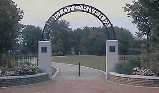
Entrance to Asheulot River Park. Digital photograph by Kenyon F. Karl on September 12, 1998.
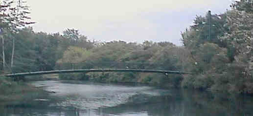
A suspension bridge near the south end of the Asheulot River Park. Digital photograph by Kenyon F. Karl on September 12, 1998.
The trail bridge near the mid-section of the Asheulot River Park. Digital photograph by Kenyon F. Karl on September 12, 1998.
The restaurant located a short distance west of the West Street entrance offers
toilets and drinking water to park visitors during restaurant operating hours.
City
Express provides city bus service within the city of Keene during the daytime hours on
weekdays only. Note that this bus does not appear to accommodate
bicycles! This bus serves the following points near the Asheulot
River Park:
Local coordination is provided by:
Friends of Pisgah


The unpaved Cheshire Branch Rail Trail begins at the west edge of the Keene Bypass Highway. However, there is no appropriate means of reaching that point from the downtown Keene Bike Path! A worn path around the end of a fence suggest that some folks risk their lives to sprint directly across the very busy highway. But a somewhat safer route involves a detour to the West Street Underpass, then returning along the grass at the west edge of the highway to the end of the rail-trail. Trail users can also continue straight west along West Street to a trail crossing about a half-mile west of the underpass.
Granite underpass at Arch Street. Digital photograph by Kenyon F. Karl on September 12, 1998.
The trail crosses Arch Street on a high embankment that sits on top of a granite arch underpass. The sheer height and steep sides of the embankment totally precludes examination of the underpass while using the trail. Thus trail users are urged to return to Arch street by other means to examine this remarkable underpass!
Solid fill has been used to replace the old highway overpass at Hurricane Road. However, a rough bypass trail has been established along the west edge of railroad right-of-way so that trail users can cross Hurricane Road at grade. Otherwise, spot checks at all road crossings on July 6, 1998 show that the railroad bed is apparently intact and used for trail purposes west and northwest of Routes 9-10-12 within the city limits of Keene.
Bypass trail at Hurricane Road. Digital photograph by Kenyon F. Karl on September 12, 1998.
Local residents can easily enter the trail at the following road crossings within Keene City Limits:
The shopping center on West Street at the
highway underpass presumably offer one or more restaurants, where
toilets and water are presumably available upon request. A major
grocery store may also be located in this area, although its existence was not specifically noted during the spot-check on
July 6, 1998.
City
Express provides city bus service within the city of Keene on
weekdays only. Note that this bus does not appear to accommodate
bicycles! This bus serves the following points near the
rail-trail:
Since City Express serves the Black Brook Development on Route 12, it is possible that a side trail might exist (or be easily cut) from the rail-trail to the end of Summit Avenue (0.1 mile) to a safe bus stop on the southbound side of Route 12. Otherwise that side trail to the end of Summit Avenue would allow trail users to walk the length of Summit Avenue (1.6 miles) to the bus stop at 800 Park Ave.
Sign images are from the Manual of Traffic Signs by Richard C. Moeur.
Updated on May 25, 2001 by Kenyon F.
Karl <[email protected]>.
Unintentional errors are likely!
