


Click on the map to browse and for access to other
information!
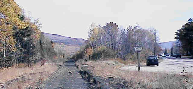
East from site of Gorham Depot. Digital photograph by Kenyon F. Karl on October 23, 1997.
The Boston & Maine Railroad Station was located on US Route 2 at the west end of Gorham Upper Village, just because of a lack of any better location in Gorham for a station on this railroad. Despite its inconvenient location, the site of the former B&M station must be considered as the easternmost trailhead for the Rail-trail!
Please note that Gorham once had two widely separated railroad stations! The Grand Trunk Railroad station still stands in the southeast corner of the Gorham settlement across the town common from the information booth. This granite structure currently houses the Gorham Historical Society, and is surrounded by historic railroad equipment.
 Very limited parking is available along the road adjacent to the
railbed at the former site of the Station.
Very limited parking is available along the road adjacent to the
railbed at the former site of the Station.


 A
sidewalk begins on the south side of Route 2 a short distance
east of the former station site, and runs east along
Route 2 about 0.9
mile to the Route 16 intersection, where a variety of restaurants and convenience stores
can be found running south from that point! Toilets and drinking water are
presumably available upon request in all restaurants.
A
sidewalk begins on the south side of Route 2 a short distance
east of the former station site, and runs east along
Route 2 about 0.9
mile to the Route 16 intersection, where a variety of restaurants and convenience stores
can be found running south from that point! Toilets and drinking water are
presumably available upon request in all restaurants.
 Hikers Paradise
at the intersection of Routes 2 & 16 offers low-cost
Hostel accommodations to trail users. The associated Colonial Comfort
Inn offers standard motel rooms at seasonably
adjusted prices.
Hikers Paradise
at the intersection of Routes 2 & 16 offers low-cost
Hostel accommodations to trail users. The associated Colonial Comfort
Inn offers standard motel rooms at seasonably
adjusted prices.
 The Concord
Trailways bus to Concord & Boston
stops at the Irving Gas & Convenience Store, a short distance
south of the intersection of Routes 2 & 16. Concord Trailways
accept bicycles on a conditional basis.
The Concord
Trailways bus to Concord & Boston
stops at the Irving Gas & Convenience Store, a short distance
south of the intersection of Routes 2 & 16. Concord Trailways
accept bicycles on a conditional basis.
Freedom
Express operates a scheduled bus service between Berlin and Gorham. Note that Freedom
Express will still provide demand-responsive
transportation between all other parts of Coos County as well as
Littleton by advance arrangement. This bus will accommodate
bicycles within the wheelchair area of the bus by advance
arrangement when the space is not otherwise occupied. A trailer
is also available to accommodate bicycle groups.
The AMC Mahoosuc Trail begins at a tiny parking
lot about 0.3 miles north of the intersection of Routes 2 &
16, and crosses the Androscoggin River on a footbridge that is
tucked within the heavy trusses of the abandoned railroad bridge.
Due to its light construction and the almost crawl-space openings
at each end, the footbridge can only be used by hikers. This
trail reaches the Appalachian Trail in 3.2 miles
(2 hours & 30 minutes) and continues across the entire length
of the mountain range to the summit of Old Speck Mountain at 27.3
miles (17 hours). Complete information about the Mahoosuc Trail
is provided in the AMC White Mountain Guide
published by the Appalachian
Mountain Club.
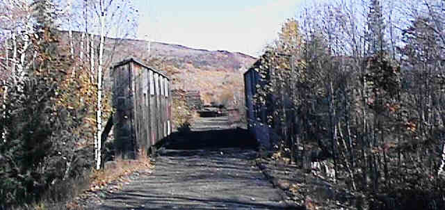
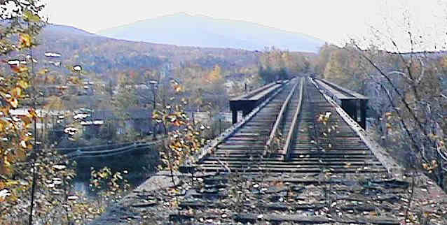
The trail continues for another quarter-mile to the wooden bridge over Moose Brook. However, this bridge has not been modified for trail users, and still contains hazardous gaps between the wooden crossties. Also, the large and active gravel pit on both sides of this railbed east of this bridge is likewise hazardous for trail users. Accordingly, the Moose Brook Bridge must be treated as the absolute east end of the trail!
East across Moose Brook Bridge. Digital photograph by Kenyon F. Karl on October 23, 1997.


 Moose Brook State Park is
located about a quarter-mile northwest of the Jimtown Road
Crossing, which is about a quarter-mile west of Gorham
Depot. Note that day-use and
camping fees are charged for the use of this state park!
Moose Brook State Park is
located about a quarter-mile northwest of the Jimtown Road
Crossing, which is about a quarter-mile west of Gorham
Depot. Note that day-use and
camping fees are charged for the use of this state park!
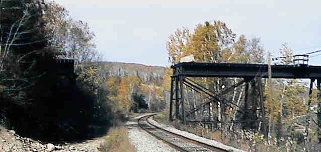
Missing bridge section at Railroad overpass. Digital photograph by Kenyon F. Karl on October 23, 1997.
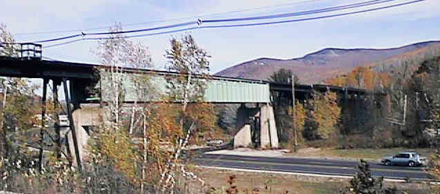
Side view of Route 16 overpass. Digital photograph by Kenyon F. Karl on October 23, 1997.
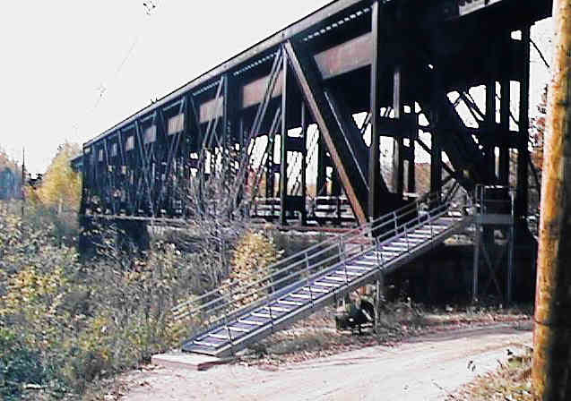
Side view of Androscoggin River Bridge. Digital photograph by Kenyon F. Karl on October 23, 1997.
Looking west across Androscoggin River Bridge. Digital photograph by Kenyon F. Karl on October 23, 1997.
A series of high bridges connected by equally high steel trestles carries the abandoned railroad across the St. Lawrence & Atlantic Railroad, Route 16, and the Androscoggin River. Unfortunately, a short section of the bridge has been removed at the far west end to accommodate double stacks of shipping containers on the very active SL&A RR. Furthermore, the high cost of adding needed decking and handrails for the great length of this bridge, and the difficulty of finding a desirable trail routing east of this point probably precludes the inclusion of this rather dramatic bridge crossing into the Rail-trail!
![]() Trespassers on the well
maintained active railroad track that parallels Route 16 are at
serious risk of death if they are struck by an unexpected freight
train!
Trespassers on the well
maintained active railroad track that parallels Route 16 are at
serious risk of death if they are struck by an unexpected freight
train!
![]() Because of the
large gaps between the wooden crossties and the lack of handrails,
the the top of this bridge formerly occupied by the railroad is
very hazardous for all forms of public usage. The sides of the
embankment that leads to the railroad bed at the east end of the
bridge are so steep as to be equally hazardous. Note
also that the railroad track that begins a short distance east of
the bridge and continues north into mill complex in Berlin is
owned by the Berlin Mills Railway for temporarily storage of
unused railroad cars. Accordingly, trespassing on the top
of the high bridge or on the railroad east and north of the
bridge is both illegal and dangerous!
Because of the
large gaps between the wooden crossties and the lack of handrails,
the the top of this bridge formerly occupied by the railroad is
very hazardous for all forms of public usage. The sides of the
embankment that leads to the railroad bed at the east end of the
bridge are so steep as to be equally hazardous. Note
also that the railroad track that begins a short distance east of
the bridge and continues north into mill complex in Berlin is
owned by the Berlin Mills Railway for temporarily storage of
unused railroad cars. Accordingly, trespassing on the top
of the high bridge or on the railroad east and north of the
bridge is both illegal and dangerous!
The trail currently ends on Route 2 at the west end of the Upper Village, because that is the last point where public access is currently feasible. However, it might be posible to extend the trail across the gravel pit towards the end of the bridge. The trail would then have to leave the railroad bed just short of the missing bridge section, then somehow descend rapidly to pass under the St. Lawrence & Atlantic RR using a small underpass that is just north of the high railroad bridge. State-owned land on the west side of Route 16 could provide limited trailhead parking, while the sidewalk and breakdown lanes would allow walking and biking to the commercial strip that runs south from the nearby Route 2 intersection. Note that the very generous cooperation of the owner of the gravel pit would be required for this trail extension!
Sign images are from the Manual of Traffic Signs by Richard C. Moeur.
Updated on February 28, 2001 by Kenyon F.
Karl <[email protected]>.
Unintentional errors are likely!
