


This trail may not be suitable for human and animal-powered users west of Barrett during the warm-weather months!
This trail may not be suitable for
human and animal-powered users west of Barrett during the warm-weather months!
|
|
![]() USGS
Topographic map of Littleton End of Trail
USGS
Topographic map of Littleton End of Trail
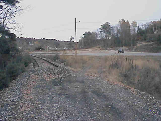
Looking east at end of track in Littleton. Digital photograph by Kenyon F. Karl on October 23, 1997.
The trail ends at the current end of track of the Whitefield-Littleton Branch of the New Hampshire and Vermont Railroad, just east of the Interstate 93 highway overpass in Littleton, and across a new bridge (Industrial Park Road). Note however that motorized trail users may be required to enter and leave the trail at a newly constructed trail access ramp just west of the I-93 overpass on Industrial Park Road. Trail parking may be available nearby.
![]() Although the State-owned railroad track northeast
of this end of the trail appears to be unused, it is still legally open for railroad
service. Thus a New Hampshire Central Railroad Train could easily appear on this
track without notice. Note also that the track and structures are
presumed to be poorly
maintained and are thus potentially dangerous for trail users!
Although the State-owned railroad track northeast
of this end of the trail appears to be unused, it is still legally open for railroad
service. Thus a New Hampshire Central Railroad Train could easily appear on this
track without notice. Note also that the track and structures are
presumed to be poorly
maintained and are thus potentially dangerous for trail users!


 Limited
groceries and various
kinds of fast food are available on Route 302 across the river from
the end of the trail (either direction from the traffic light). Toilets and drinking water are presumably available at
each of the restaurants upon request. A public phone is located next to the
entrance to McDonalds Hamburger Stand.
Limited
groceries and various
kinds of fast food are available on Route 302 across the river from
the end of the trail (either direction from the traffic light). Toilets and drinking water are presumably available at
each of the restaurants upon request. A public phone is located next to the
entrance to McDonalds Hamburger Stand.
 Freedom
Express provides local public transportation on a demand responsive basis within
Littleton and to all of Coos County on weekdays only. Freedom Express accommodates bicycles in the wheelchair area of the bus by
advance request when that space is not required by a wheelchair
passenger. A trailer can also be attached to the Freedom Express
bus by advance request to accommodate a group of bicyclists. Trail users that
plan on boarding this bus near the Littleton Trailhead are advised to call Freedom Express in advance
for general scheduling purposes, with the promise to call again upon arrival (from
a cell phone or public phone on Route 302) to make final arrangements for pickup.
Freedom
Express provides local public transportation on a demand responsive basis within
Littleton and to all of Coos County on weekdays only. Freedom Express accommodates bicycles in the wheelchair area of the bus by
advance request when that space is not required by a wheelchair
passenger. A trailer can also be attached to the Freedom Express
bus by advance request to accommodate a group of bicyclists. Trail users that
plan on boarding this bus near the Littleton Trailhead are advised to call Freedom Express in advance
for general scheduling purposes, with the promise to call again upon arrival (from
a cell phone or public phone on Route 302) to make final arrangements for pickup.
RCT Shuttle
operates a scheduled between Littleton and St. Johnsbury VT on
weekdays only. Trail users must inquire whether the stop at Littleton
Industrial Park is close to the end of the rail-trail or otherwise whether the
bus will stop at a suitable place on Route 302 near the end of the bridge. Bicyclists
and x-c-skiers must also inquire whether bicycles/skis will be accommodated
aboard this bus.
Concord Trailways
provides daily bus service between Boston-Concord-Littleton at the Irving Gas Station at the south end of
Cottage Road adjacent to I-93 Exit 41. To avoid the heavy traffic
on Route 302, trail users are advised to use the
obscure town streets on the south side of the river to reach the bus station. Concord
Trailways accommodates bicycles on a conditional basis!
Each location map on this Web Site is a link to a map on the Mapblast Web Site which in turn contains a link to a Business Directory of the surrounding area.
 Listed on the
National Register
of Historic Places:
Listed on the
National Register
of Historic Places:![]() The address lookup function of the Mapblast
Web Site will provide location maps of these places.
The address lookup function of the Mapblast
Web Site will provide location maps of these places.
Sign images are from the Manual of Traffic Signs by Richard C. Moeur.
Updated on March 05, 2001 by Kenyon F.
Karl <[email protected]>.
Unintentional errors are likely!
