LandView III is a desktop mapping system that includes database extracts from the Environmental Protection Agency, the Bureau of the Census, the U.S. Geological Survey, the Nuclear Regulatory Commission, the Department of Transportation, and the Federal Emergency Management Agency. These databases are presented in a geographic context on maps that show jurisdictional boundaries, detailed networks of roads, rivers, and railroads, census block group and tract polygons, schools, hospitals, churches, cemeteries, airports, dams, and other landmark features.
The mapping software in LandView III is an adaptation of MARPLOT, part of the CAMEO system (Computer-Aided Management of Emergency Operations). MARPLOT was developed by the Hazardous Materials Response and Assessment Division, National Oceanic and Atmospheric Administration. The database software LandView III was developed at the Chemical Emergency Preparedness and Prevention Office, Environmental Protection Agency, Washington, DC.
The full version of Landview III software will run on Windows 3.1, Windows 95, and Windows 98 computers as well as Macintosh computers. A CD-ROM containing the full version of this software as well as the data for any Census Region (multi-state) of the United States can be purchased from the Census Bureau for $99. An eleven-disk set for the entire United States is also available at $549.
Note however that a limited version of Landview III software for Windows along with a complete set of data for any given county of the United States can be downloaded from the Web without charge (except for the user's normal internet connection charges). Despite its limitations, this free download version of the software and its associated data files appears to be almost adequate for most rail-trail mapping projects, if trail volunteers are willing to produce a separate map for each county that their trail happens to traverse.
This software and its associated data follows the general principles of any 'GIS' (Geographic Information System). Users can accordingly choose both the scope and scale of the map display, and likewise choose which 'layers' of map data to display. But even better yet, users are able to update the map to correct some errors, and extremely patient folks can even hand-edit the underlying data files to make detailed corrections to the resulting map display.
Any given map display can be saved in Windows Bitmap format, to be edited in a wide variety of graphics software packages and saved in any of several computer formats for reproduction in their various publications and Web Pages. Indeed, because the map data is taxpayer supported, organizations never need to worry about copyright permissions. Even better yet, since the Landview III software can be downloaded from the web by any technologically proficient Web Site Visitor, the Webmaster can also distribute the trail organization's version of the map files so that these potential trail users can scroll and zoom around the complete county-wide map (that includes the trail map) as they so choose.
Rail-trail organizations must note that the Census GIS data base often contain lines for railroads that have been abandoned for the last 25 years or more. Furthermore, some of the lines for even older railroad abandonments may be represented on the map as minor roads and the like. Accordingly, the most important mapping task for many rail-trails will require that the mere identification of those sections of the railroad bed that have been converted for trail usage. The map representation for those particular segments can then be shifted from the 'railroad' layer to a brand new 'rail-trail' layer, with associated changes to the map line to clearly indicate that it has become a trail. In addition, each section of the trail can be color-coded to indicate its current status (i.e. 'proposed', 'construction', 'open', etc.), and easily changed on a month by month basis to reflect the progress of the trail conversion effort.
One set of symbols can be added to the map to indicate the historic station sites that are referenced in rail-trail mileage charts (based upon from old railroad station lists). Other symbols should be added to the map to indicate important trail facilities (parking, toilets, food service, camping, information booths, etc.) as well as nearby attractions (historic, scenic and natural areas, and the like). In addition, the color-codes of nearby streets should likewise be changed to indicate public transit lines and designated bike routes.
Because of its origins within the Federal Bureaucracy, there is no commercial incentive to publicize its availability beyond a few obscure governmental Web Pages. But even worse, the Landview III software uses a totally unique format for its data files, so that it is impossible to utilize mapping files from any other source of GIS files. Because the few folks that do stumble across this software will quickly dismiss their 'find' because its incompatible file structure, Landview III is almost unknown outside of its primary group of users!
The most important drawback of the Landview III software for trail mapping purposes is its inability to accept fresh mapping data from consumer-grade GPS (Global Positioning Satellite) receivers. Accordingly, the Webmaster has written some simple computer programs that bridges the gaps between otherwise incompatible file formats. These programs allow a trail volunteer to map otherwise missing sections of the trail (and/or important side trails) by simply walking or biking the trail with a consumer-grade GPS (Global Positioning Satellite) receiver. The 'tracklog' feature of the GPS will automatically record the trail user's position at specified time intervals, and thus collect the string of data points required to properly map the trail. This 'tracklog' feature can likewise map otherwise missing streets and roads that are important to trail users. Furthermore, the 'waypoint' feature of the GPS can be used to record the locations of important trail facilities as well as the important off-trail points of interest for bicycle tourists and the like. When the trail volunteer returns to their laptop or desktop computer, the data is easily uploaded using a GPS utility program. After using the Webmaster's new program to convert the file format to Landview III specifications, the 'import' function of that software will add the tracklog and waypoints to the user's version of the map database.
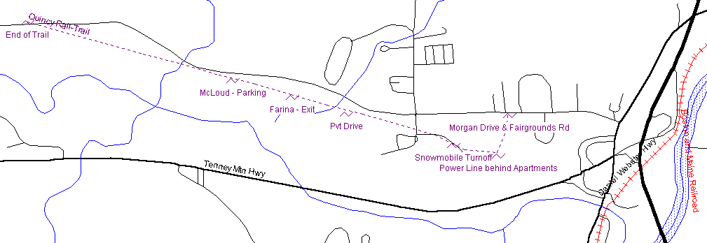
This example map is the eastern segment of the Quincy Rail-trail that runs along Fairgrounds Road in Plymouth NH. The purple line was added to the map using the 'tracklog' function of the GPS receiver, while the named locations were recorded with the 'waypoint' function. The trail name was added during the format conversion, while the names for the points of interest were changed from code numbers to meaningful names within the Landview III program. Interstate highways (I-93 at far right) were moved to a new layer so that they could be shown with a particularly wide line for emphasis. But otherwise, all other map lines remain unchanged from the Grafton County map data that was downloaded with the Landview III program from the Web. This graphic was copied from the screen of the Landview III program in bitmap format, then cropped and converted to 'GIF' format using commonly available graphic software.
The executable code for this format conversion software is available for downloading without charge from this Web Page. However potential users must note that this software requires the use of particular software packages for uploading the collected GPS data to a desktop or laptop computer, which in turn requires the use of specific brands and models of GPS receivers. Furthermore, the programming effort is amateurish at best, and no documentation is provided beyond that which is posted to this Web Site. Accordingly, many potential users will certainly decide that this software is useless for their purposes!
As trail volunteers work with the map data, they may discover significant differences between the map data and their field observations. Any anomalies in the Landview III map layers that are based upon the TIGER database should be reported to a Regional Geographer in the appropriate Census Bureau Regional Office as determined from the Web Page at <http://www.census.gov/field/www/>. [requested by Paul Manka <[email protected]> August 24, 2000 5:30 PM]
Unfortunately, the Landview III software uses a totally unique format for its data files, so that most potential users decide rather quickly that it is impossible to utilize mapping files from any other source of GIS data. Accordingly, the Webmaster has written a somewhat more complex computer programs that bridges the gap between the following otherwise incompatible file format:
Note that the Beta Version 11d of GPS Trackmaker (freeware) can read either a ESRI ArcVew Shape file (.shp) or ESRI ArcInfo Export file (.e00) and write them in Waypoint+ 'tracklog' text file format. The Webmaster's 'wptl-mie' program can then be used to convert the intermediate file into the Landview III MIE format. This indirect route may be useful as a temporary expediency (not tested by the Webmaster) for Polyline (streets, streams, etc.) and Polygon (lakes, boundary lines, etc.) files from the ESRI ArcInfo Export file (.e00). This indirect route may also be useful if the preceeding 'shpf-mie' program is dysfunctional, or its inability to correct for differences in Datum leads to unacceptable errors. Because this usage was not anticipated in the design of the 'wptl-mie' program, minor hand-editing of the resultant MIE file may be required just before its import into Landview III system. Note also because of the severe limitations of the Waypoint+ 'tracklog' text file format, feature names (street names, stream names, lake names, boundary identifications, etc) and other attribute information present in the GIS file can not be passed on to the Landview III system!
To help integrate Atlas GIS into the ESRI product family, ESRI provides freely downloadable Atlas Geo File (.AGF) translators. Note that the Webmaster has not tested the resultant two-step process for converting ESRI Atlas Geo File into Landview III MIE files.
This free utility program available on a rather obscure page on the ESRI Web Site lets you use MapInfo data files (.mif) by converting it to shapefiles (.shp) . Note that the Webmaster has not tested the resultant two-step process for converting Mapinfo files into Landview III MIE files.ArcExplorer is a lightweight GIS data viewer developed by ESRI that can be downloaded for free at the ESRI Web site. As a complete data explorer, ArcExplorer lets you display and query a wide variety of standard data sources. Using ArcExplorer as a stand-alone desktop application, you can view and query industry-standard ESRI shapefiles, ArcInfo coverages, and ArcSDE (Spatial Database Engine) layers. You can also pan and zoom through multiple map layers and identify, locate, and query geographic and attribute data. Use ArcExplorer software's powerful symbolization tools to create thematic maps based on attributes contained in the database, and even perform basic statistical analysis on the geographic data.
This ESRI ArcInfo format is supported directly by the Landview III system, but this format may be obsolete since the Webmaster is unable to find any mention of it on the ESRI Web Site!
The Bureau of Transportation Statistics of the US Department of Transportation issues the The National Transportation Atlas Data (NTAD) on CD-ROM on an annual basis containing GIS files for passenger and freight transportation facilities of national significance. The Bureau also issues the North American Transportation Atlas Data (NORTAD) on CD-ROM on a less frequent basis to include corresponding GIS files for Canada and Mexico. Each of these disks is available without charge through the BTS Web Site. Note that data from these disks can also be downloaded from the free data section of the Manifold Web Site. The data on these CD-ROM disks is formatted using a unique file format composed entirely of ASCII characters to ease the task of writing format conversion programs. Also included on the CD-ROM is the BTS Data Converter that converts this format into the Landview III internal file format as well as several common GIS formats.
A few quick tests of the BTS Data Converter suggests that attempts to extract data files limited to a particular region or state will not produce any data. An extraction of railroad data for the entire country in the Landview III internal format lead to a map that appears to shows the entire railroad system as it was a few decades ago. This GIS database accordingly includes trails that utilize relatively recent railroad abandonments, but excludes existing and potential trails based upon previous abandonments. Indeed, the railroad coverage of this database may be similar (or identical) to the TIGER database. Accordingly, attempts to use this database for mapping rail-trails on a State-wide or regional basis must expect to obtain supplementary files from other sources.
Note that the files converted directly to the internal format of the Landview III system did not show the names of the active railroads. It likewise failed to identify the many recently abandoned railroads in its database. Indeed, the text of the documentation of the BTS Data Converter suggests that the absence of such 'attribute data' must be anticipated. Although the Webmaster has not tested it on an end-to-end basis, the following general procedure may be required for some or all BTS map files:
Once all of the desired lines have been entered into the Landview III file system, the map editing capabilities can be used to move the rail-trails into a separate layer, and likewise change the color-codes to reflect the important differences between the trails:
Since rail-trails are usually isolated from each other, the following should also be added to the map:
The Webmaster also feels that public transportation services should be added to rail-trail maps, particularly those services that gracefully accommodate bicycles, skis, and the like:
Because of the great importance of automobile transportation in this country, a map must also be considered that shows the relationship of the rail-trails to the interstate and primary highway system. This map might also show the airports that feature scheduled airline service, and as well as the airports that can be used by private aircraft.
Last but not least, the Webmaster strongly suggests the creation of a separate map be created that shows the active railroads of the State and region, as an important means of reminding trail users of the hazards of 'trespassing' on active railroad lines!
The Webmaster invested in the series of Maptech Landscape Navigator CD-ROM disks before Topographic Maps could be examined without charge on the Web through the Topozone Web Site. Nevertheless, this expensive series of CD-ROM disks has been extremely valuable to the Webmaster when performing automobile-based field-checks of existing and potential rail-trails with the aid of a laptop computer and an attached GPS receiver. Even better yet is the possibility that purchase of this series of CD-ROM disks will allow users of Landview III to desk check and edit GPS tracklog files against the topographic map. The software even allows folks to desk-sketch the approximate route of a trail on the topographic map, then extract the 'track' file in the same manner as if it had been collected with a GPS receiver!
* promised items!
The Webmaster feels that it is worth the effort to create a GPS 'route' file for each rail-trail, for distribution to potential trail users through the Trail Web Site. Note that a GPS 'route' file consists of a set of GPS 'waypoints' for the significant points on the trail, presented in correct (or reverse) geographic order for trail users, arranged for download to the GPS receiver before usage of the trail. This file allows trail users to find the desired trail entrance, monitor their progress towards the particular trail facilities and trail exits that they plan to use, and improve their ability to choose a wise course of action in the event of an emergency on the trail. A route file that might be assembled for potential trail users to accompany the trail map on this page could include the following points:
Trail users must note however that a GPS 'route' file for a given trail assumes that the trail takes the form of a straight line between each pair of 'waypoints' along the trail. Accordingly, trail users that are not paying attention to such details may be disconcerted by the noticeable differences between the mileage and route as shown on their GPS receiver and what they experience while using the trail.
It is the Webmaster's current practice to create GPS 'route' files for potential trail users by use of the Maptech Landscape Navigator software. Until this point, these trail users were advised to use the free demo version of this software to load the finished 'route' file(s) into their GPS receiver for use on the trail. However the availability of the format conversion program (mtr-wprp) will enable the Webmaster to also distribute these GPS 'route' files in the text version of the Waypoint+ 'route' format so that users of any one of the four GPS utilities will be encouraged to use the appropriate file as they traverse the associated rail-trail. Links to Web Sites that serve as the software distribution sites would likewise encourage GPS owners to acquire and use whatever utility software was appropriate to their particular GPS receiver.
Last but not least, the Webmaster suggests the preparation of a GPS 'waypoint' file for trail users, containing the coordinates of mountain peaks and other scenic points easily visible from the trail. Trail users that are curious about such things can accordingly use their GPS receiver to provide the distance and bearing from their current position to any point in the GPS 'waypoint' file. This file might likewise be helpful in answering any questions about the current distance and bearing to other off-trail points that are of particularly importance to trail users.