


|
|
![]() USGS
Topographic map of Wambek Jct
USGS
Topographic map of Wambek Jct
The B&M Railroad applied the name 'Jefferson' to three very different points in this area at various times. To reduce confusion, the Webmaster will use the name that the railroad used in 1983, and is used on many maps of the area.
Wambek Jct. is located at the west end of the Cherry Pond section of the Pondicherry Wildlife Refuge. There is apparently no road access to this point. However, a well-groomed snowmobile trail was observed crossing Airport Road (portions unpaved, also called Hazens Road) a short distance southeast of the Mt. Washington Regional Airport and adjacent to the southeast corner of a large green electric generating plant. This trail runs approximately 1.5 miles northeast on the Maine Central Railroad bed to Wambek Jct.
The best route from downtown Whitefield for 'street legal' trail users (hikers, bikers, etc.) is straight east to the junction of Route 116 & Hazen Road, then southeast to the railroad crossing at Hazens. They must then turn east at the nearby intersection to pass the airport, and continue southeast past the generating plant to reach the snowmobile trail crossing. Folks leaving the trail should travel northwest past the airport, turn north at the intersection next to the railroad crossing, then turn west onto Route 116 to reach Whitefield.
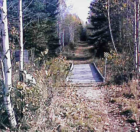
Connecting Snowmobile trail from Airport Road. Digital photograph by Kenyon F. Karl on October 23, 1997.
![]() The New Hampshire Central Railroad has signed an agreement
in January 2001 with NH-DOT to operate the State-owned railroad track that
runs from Groveton south to Wambeck Jct., then west through Hazens and downtown
Whitefield to Littleton. Although train speeds are likely to be about 10
mph, the trains might be heavily loaded at times and thus difficult to stop.
Furthermore, the railroad track and structures have not been maintained beyond
the level required for the safe passage of trains at these very slow
speeds. Trail users are accordingly warned to stay away from the railroad
track!
The New Hampshire Central Railroad has signed an agreement
in January 2001 with NH-DOT to operate the State-owned railroad track that
runs from Groveton south to Wambeck Jct., then west through Hazens and downtown
Whitefield to Littleton. Although train speeds are likely to be about 10
mph, the trains might be heavily loaded at times and thus difficult to stop.
Furthermore, the railroad track and structures have not been maintained beyond
the level required for the safe passage of trains at these very slow
speeds. Trail users are accordingly warned to stay away from the railroad
track!
There is no trail access, nor trail facilities of any kind at Wambek Jct!

 The Mount Washington Regional Airport just north of the Airport
Road Trailhead is a tiny general aviation airport (limited to
private airplanes). There should be ample parking for warm
weather trail users on the dead end roads on the southwest
portion of the airport grounds. Because of the absence of on-site
personnel, normal airport facilities are presumably not
available to trail users except for emergency purposes!
The Mount Washington Regional Airport just north of the Airport
Road Trailhead is a tiny general aviation airport (limited to
private airplanes). There should be ample parking for warm
weather trail users on the dead end roads on the southwest
portion of the airport grounds. Because of the absence of on-site
personnel, normal airport facilities are presumably not
available to trail users except for emergency purposes!


 A convenience store is
located on the west side of the Whitefield Commons. A public phone,
toilets, water, and cold sandwiches are available at that
store.
A convenience store is
located on the west side of the Whitefield Commons. A public phone,
toilets, water, and cold sandwiches are available at that
store.

 A donut shop and a laundromat occupy the former B&M RR Station north of the
Whitefield Commons across the river bridge. Toilets and water are presumably available at
the donut shop upon request.
A donut shop and a laundromat occupy the former B&M RR Station north of the
Whitefield Commons across the river bridge. Toilets and water are presumably available at
the donut shop upon request.
 Freedom
Express provides local public transportation on a demand responsive basis within all of Coos County. Freedom Express accommodates bicycles in the wheelchair area of the bus by
advance request when that space is not required by a wheelchair
passenger. A trailer can also be attached to the Freedom Express
bus by advance request to accommodate a group of bicyclists. Trail users that
plan on boarding this bus at Whitefield are advised to call Freedom Express
in advance
for general scheduling purposes with the promise to call again upon arrival from
a public phone in downtown Whitefield to arrange to make final arrangements for pickup. Trail
users with cell phones should make that second call upon arrival at Airport
Road.
Freedom
Express provides local public transportation on a demand responsive basis within all of Coos County. Freedom Express accommodates bicycles in the wheelchair area of the bus by
advance request when that space is not required by a wheelchair
passenger. A trailer can also be attached to the Freedom Express
bus by advance request to accommodate a group of bicyclists. Trail users that
plan on boarding this bus at Whitefield are advised to call Freedom Express
in advance
for general scheduling purposes with the promise to call again upon arrival from
a public phone in downtown Whitefield to arrange to make final arrangements for pickup. Trail
users with cell phones should make that second call upon arrival at Airport
Road.
Each location map on this Web Site is a link to a map on the Mapblast Web Site which in turn contains a link to a Business Directory of the surrounding area.
Note that Tributary Trails plans to cut a primitive hiking trail that will run along the Johns River from Hazens Road (near the railroad crossing) to downtown Whitefield.
There are two independent sets of railroad tracks between downtown Whitefield and Hazens Road, both of which are State-owned. The southern of the two tracks has been severed at the Hazens Road end, and is thus totally useless except for a short stretch approaching downtown Whitefield. Thus, it is reasonable to ask NH-DOT Bureau of Rails to remove the tracks and ties from that roadbed so that unused track bed can be used as a rail-trail extension to reach Route 3 at the edge of the Whitefield settlement.
I can tell your from experience, that the Snowmobile path (Ex MEC Row) does lead to the junction, it is a nice ride and could be part of the trail. The line to Gorham after the junction still has track although unused.
I am from Mystic, CT but have vacationed in this area over the past few years. I have explored most of the RR in the area.
Sign images are from the Manual of Traffic Signs by Richard C. Moeur.
Updated on February 28, 2001 by Kenyon F.
Karl <[email protected]>.
Unintentional errors are likely!
