Click on the map to browse!
![]() USGS
Aerial photograph of Westboro
USGS
Aerial photograph of Westboro
The Upper Valley Trails Alliance advocates a rail-with-trail across the Connecticut River in its fact sheet 'An Upper Valley Loop Trail? which it issued in June of 2000. Their proposal is similar to what follows!
The unused south half of the Connecticut River railroad bridge could easily be used as a multi-purpose trail as a result of the new Rail-with-trail concept currently being advocated by the national Rails-to-trails Conservancy. This path has the advantage of being a very pleasant as well as the most direct route between the old commercial center of West Lebanon and the old commercial center of White River Junction. But even more important, this path would instantly become the safe bicycle route across the river, just because of the substantial hazards of trying to share the narrow and busy traffic lanes of the Bridge Street crossing.
Rail-with-trail is a totally new concept in New Hampshire that involves the construction of multi-use trails on otherwise unused slivers of land alongside active railroad tracks. The adjoining railroad will have legitimate safety concerns based upon their tragic nationwide experience with unauthorized pedestrian use of railroad tracks. However, a recently released study by the Rails-to-Trails Conservancy clearly establishes the excellent safety record of several trails are located in close proximity to active railroad tracks. There were numerous differences between the trails that were studied - as well as the nature of the rail traffic that was present on the adjacent railroad track. The techniques used to keep trail users away from the tracks varied from nothing more than an additional rule for trail users on a low-speed line used for tourist trains - to the construction of a full-height chain-link fence or similar barrier between the trail and the railroad track used by high-speed commuter trains and/or heavy freight trains.
The obvious opportunity for a Rail-with-trail begins adjacent to the southwest corner of the Route 12A railroad overpass. The trail would begin by following a currently blocked-off asphalt ramp down to track level. But the trail would promptly leave this asphalt lane to cross a field directly to the service road north of the abandoned turntable pit to avoid the abandoned environmentally hazardous roundhouse area. The trail would then follow the service road as it curved onto the otherwise unused rail-bed on the south half of the bridge, adjacent to the active railroad track.
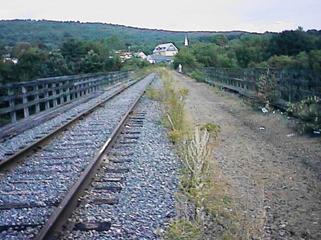
East from center of Connecticut River Bridge. Digital picture by Kenyon F. Karl on September 24, 1997. This picture can be sent to any Netizen as a Free Virtual Postcard.
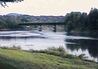
Side view of Connecticut River Bridge. Digital picture by Kenyon F. Karl on September 24, 1997. This picture can be sent to any Netizen as a Free Virtual Postcard.
A detailed safety study of this trail would determine whether a continuous fence is required between the trail and the railroad track. This safety study would also determine whether an otherwise very desirable side trail should branch off of the curved portion of the service road to cross the field then the active railroad track to a second asphalt lane that leads directly into the commercial center of West Lebanon and its associated Advance Transit Bus stop.
Detailed planning work would also be required to determine the most appropriate means of closing the one-mile gap in the trail south of the Route 12A highway overpass in a manner that avoids the very dangerous industrial land uses near Glenn Road. One important possibility is the construction of bike lanes on Route 4 over Seminary Hill and thence across the bridge to a trailhead in the Miracle Mile area.
In the meantime, hikers and bikers might be advised to consider the following alternatives:
Walk on the narrow residential sidewalk or bike in the narrow traffic lanes of Route 12A south to Glenn Road, then east to the Bascetta Park trailhead.
Walk on the narrow residential sidewalk or bike in the narrow traffic lanes of Route 4 over Seminary Hill then across the bridge to the Miracle Mile trailhead.
Ride the Advance Transit bus between the West Lebanon Bus Stop and the Powerhouse Mall Bus Stop then walk or bike to the nearby trailhead. Regular commuters might prefer to ride the bus to the Miracle Mile Bus Stop instead. Note that all Advance Transit busses now have exterior bike racks with a capacity of two bikes. Note that a special shuttle bus might be operated to bridge this gap in the trail if sufficient numbers of trail users are willing to utilize this special bus service.
Click on the map to browse!
![]() USGS
Topo map of White River Junction
USGS
Topo map of White River Junction
![]() USGS
Aerial photograph of White River Junction
USGS
Aerial photograph of White River Junction

White River Jct Railroad Station. Digital picture by Kenyon F. Karl on April 30, 1999.
East from White River Jct Railroad Station. Digital picture by Kenyon F. Karl on September 24, 1997.
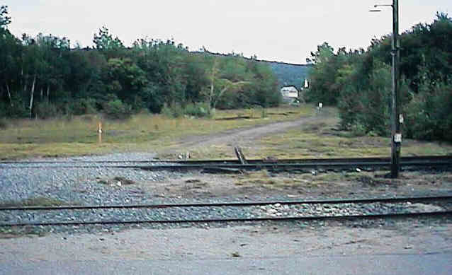
Shortly after crossing the Connecticut River Bridge on the unused rail-bed, the trail would then follow the service road across the active railroad tracks to the White River Junction Railroad Station. This railroad station is still served by a daily Amtrak train (WRJ).
Boston & Maine Engine 494 is currently on static display adjacent to the White River Junction Railroad Station.
A railroad crossing just north of the Station leads to the White River Junction Historic District. Ample free parking is usually available in the municipal lot. A couple of restaurants and a few other stores are located in the immediate area. The nearby Coolidge Hotel offers both standard hotel rooms and inexpensive hostel accommodations. The local Advance Transit Bus stop is near the hotel.
A major bus terminal for Vermont Transit Bus Line (Greyhound) is located on Sykes Street about a mile up the hill near Route 5 and the I-91 exit. The Advance Transit Bus also stops at the Bus Terminal.
 Listed on the National
Register of Historic Places:
Listed on the National
Register of Historic Places:Sign images are from the Manual of Traffic Signs by Richard C. Moeur.
Updated on February 14, 2001 by Kenyon F.
Karl <[email protected]>.
Unintentional errors are likely!
