|
|
|
|
![]() USGS
Topographic map of Brattleboro
USGS
Topographic map of Brattleboro
The railroad bridge at the Brattleboro end of the Fort Hill Branch is still in place, and is thus potentially usable for a future extension of the Rail trail into Brattleboro. However the spot-check of this railroad bridge conducted on May 19, 1998 reveals that this railroad bridge is totally unsafe for trail purposes at this time. A lack of cooperation by the public agencies and potential trail supporters in Vermont may be a major contributor to the problem of extending the trail into Brattleboro!
Rail-trail advocates must note that a new highway bridge across the river is being planned to replace the existing Route 119 bridges. If these supporters pay attention to this project during its planning phase, it may be possible to incorporate a means of trail access for the Brattleboro end of the Rail-trail into the detailed design of that bridge. Note also that the highway planners have already stated that the old Route 119 bridges would be left in place to serve trail users. Thus appropriate design of the Brattleboro Trailhead of the Fort Hill Rail-trail must also allow trail users to continue back into NH over the old Route 119 bridges to reach the Wantastiquiet Mtn. Natural Area.
Note that the availability of bicycle accommodations aboard Amtrak's Vermonter which stops at the nearby Brattleboro Station is another important reason to support a well designed trail extension. Bicycle tourists would thus be able to ride the train from any point on the Northeast Corridor to Brattleboro, then use the Fort Hill Branch and the Asheulot Branch Rail-trails to reach Keene. A northern extension of the Cheshire Branch Rail-trail to Cold River and a bike route into the Bellows Falls station would likewise enable tourists to complete a circular bike tour to return home on the Vermonter.
As a temporary expediency, a modest trailhead near the Brattleboro Sewage Plant could connect to a bike route that eventually leads through the industrial park to the nearest bus stop of the Brattleboro Town Bus. If that bus was equipped with bike racks, rail-trail users would thus be able to ride the bus through the busy city streets to the Amtrak station, the Vermont Transit bus station, various restaurants and grocery stores, or the edge of town in any direction!
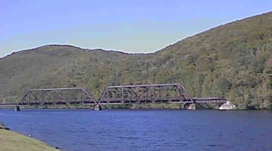
Side view of Connecticut River Bridge into Brattleboro. Digital photograph by Kenyon F. Karl on May 19, 1998.
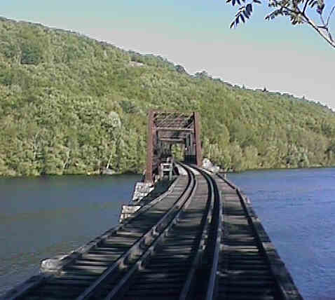
End view of Connecticut River Bridge from Brattleboro. Digital photograph by Kenyon F. Karl on May 19, 1998.
Bike trail backers eye river corridor (May 22, 2001 - Brattleboro Reformer)
New Chesterfield bridge set for construction next year (March 28, 2001 - Brattleboro Reformer)
State officials firm up Hinsdale bridge plans (June 07, 2000 - Brattleboro Reformer)
Sign images are from the Manual of Traffic Signs by Richard C. Moeur.
Updated on July 23, 2001 by Kenyon F. Karl <[email protected]>.