|
|
Local coordination is provided by:
Friends of Pisgah|
|
![]() USGS
Topographic map of Fort Hill
USGS
Topographic map of Fort Hill
A spot check made at the presumed location of Fort Hill station on May 19, 1998 shows a completed rail-trail bridge across the Asheulot River, as well as a lightly used trail in both directions. Other spot checks suggests that the trail is usable from this point north only. However, this section of the rail-trail certainly invites exploration!
Note that the Fort Hill Station is reachable from the Hinsdale settlement via River Street, the beginning of which is marked by a sign for the town Police Department, and Highway Department. Trail users should continue past these points and also past a sign stating that the road is subject to gates and bars onto a section of road that appears to be abandoned. The road apparently continues through a narrow underpass, while an adjacent gated ramp provides access to the the railroad bed.
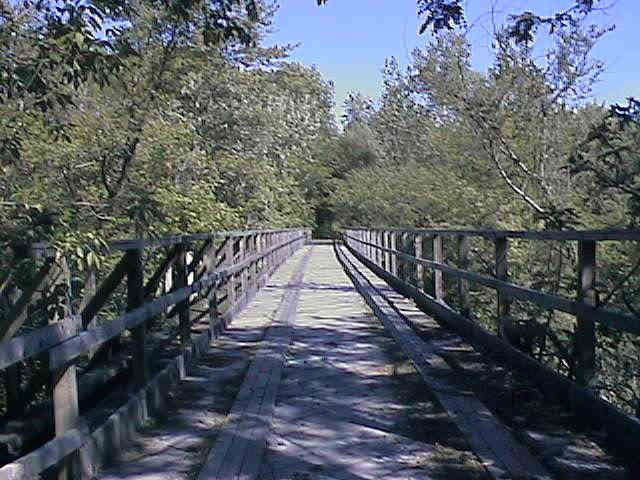
Asheulot River Crossing near Fort Hill station. Digital photograph by Kenyon F. Karl on May 19, 1998.
 There is room to park a limited number of cars in
the road junction near the gated ramp to the top of the
railroad embankment.
There is room to park a limited number of cars in
the road junction near the gated ramp to the top of the
railroad embankment.
 The Police
Department can be found on River Road halfway to the intersection of Routes 119
and 63.
The Police
Department can be found on River Road halfway to the intersection of Routes 119
and 63.
Trail users must note that River Street, Main Street, and Depot Street forms a reasonable hiking and biking route to the usable portion of the Asheulot Branch Rail-trail at the Hinsdale Station, although bikers must contend with the hazards of parked cars and moderate traffic on the Main Street portion of this route.


 The Post Office, the Hinsdale
Public Library, and a small convenience store can be found in the Hinsdale
Business District just before the turn to go uphill on Depot Street to the Hinsdale
Station.
The Post Office, the Hinsdale
Public Library, and a small convenience store can be found in the Hinsdale
Business District just before the turn to go uphill on Depot Street to the Hinsdale
Station.
A section of the Fort Hill Branch railroad bed is open for vehicle usage near the northwest corner of the Hinsdale settlement. This section begins at a ramp from the boat ramp at the north end of Prospect Street and runs across a high causeway north to a parking area just north of a power line crossing that is used for fisherman access to an island in the Connecticut River. This section of the railroad bed was noted as horribly rutted during a spot-check made on July 6, 1998.
Ample parking for trail users is obviously available
at each end of this section, as well as along the wide connecting
railroad bed.
No other trail facilities were observed within a reasonable distance of the trail!
The currently usable section of the Fort Hill Branch apparently ends at a large orange barrier just north of the back end of a signed highway picnic area a short distance south of the Hinsdale Greyhound Track. An apparent lack of parking facilities and public access points north of this point may have contributed to a decision to erect a barrier at this location.
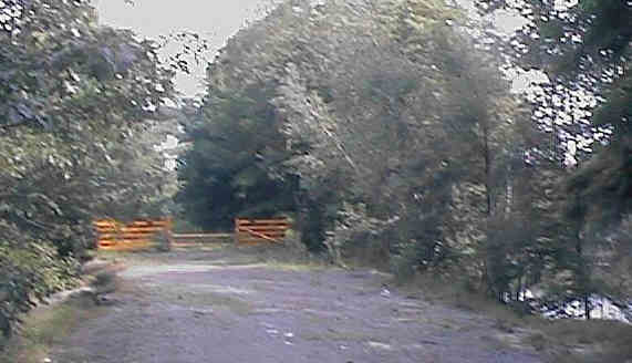
Barrier at north end of Fort Hill Rail-trail. Digital photograph by Kenyon F. Karl on July 6, 1998.
Click on the map to browse!
Parking at the
State Picnic Area is limited to perhaps two
cars. The unsigned paths to the Rail-trail at the back of the
picnic grounds are narrow and steep and thus not suitable for wheelchair users
and the like.
Despite the highway sign, none of the typical picnic area facilities were present during a spot-check made on July 6, 1998.
Sign images are from the Manual of Traffic Signs by Richard C. Moeur.
Updated on February 26, 2001 by Kenyon F. Karl <[email protected]>.
