

| Miles | Station | Municipality |
|---|---|---|
| 51.26 | Plymouth | Plymouth |
| 56.60 | Quincy | Rumney |
| 58.96 | Rumney | Rumney |
Railroad Miles from Concord.
Bold face indicates telegraph station in 1923
Italic face indicates point beyond end of rail-trail
|
|
|
|
![]() USGS
Topographic map of Quincy
USGS
Topographic map of Quincy
The Quincy Rail-Trail is part of the Snowmobile trail system maintained by the Rumney Trail Busters. As such, this trail is officially closed during the warm months of the year. Note that local information about the club and its trails should be available during business hours at McLeod's small engine shop, located in a red barn on Fairgrounds road about half-way between the Cooksville Road and Loon Lake Road trailheads. Trail maps are sometimes available in local stores for $2.00 each.
Three portions of the Rail-trail are apparently usable during the warm weather months:
The Easternmost trailhead is reachable from the McDonalds Hamburger Stand on Route 3 north of downtown Plymouth, by traveling west on Fairgrounds Road about 0.9 mile to Cooksville Road, then south about 350 feet to the power line crossing. This segment of the trail runs straight west under the power line about 1.6 miles until it ends at an oblique crossing of Fairgrounds Road east of Loon Lake Road. Snowmobilers somehow bypass a horse farm that straddles the railroad bed at this point, but warm weather users can easily use Fairgrounds Road for about 1100 feet west and then turn north onto Loon Lake Road to reach the next section of the trail.
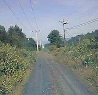
The Center section begins under the power line on Loon Lake Road about 400 feet north of Fairgrounds Road, and runs straight west under the power line about 1.8 miles to an oblique crossing of Quincy Road in Quincy at the presumed location of Quincy Station. Warm weather users are advised to leave the rail-trail at this point to continue west and north to the usable section of the Wentworth Rail-trail via Quincy Road, Buffalo Road, and East Side Road.
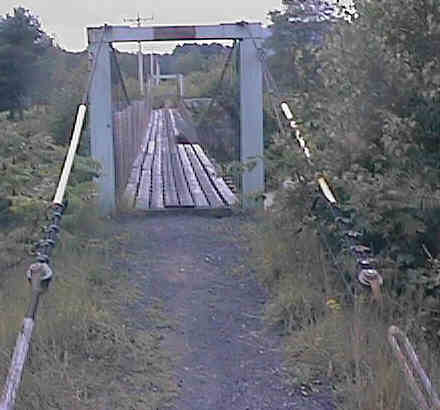
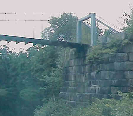
The Western section continues about 1.2 miles straight west from Quincy Road to School Street at the south end of the Rumney Depot Settlement, crossing the Baker River on a suspension bridge about 0.9 mile west of Quincy Road. However, this segment of the trail is currently broken by barbed wire fencing a short distance east of the Baker River bridge during the warm weather months!
 An undesignated
bike route is available between Warren, Wentworth, and
Plymouth over the following roads:
An undesignated
bike route is available between Warren, Wentworth, and
Plymouth over the following roads:
 An interpretive nature trail
runs around the edge of Quincy
Bog. The bog can be reached by traveling
northwest a short distance from the Quincy Road Crossing (Site of Quincy
Station) then following the signs to the bog. (The site is administered by
Rumney Ecological Systems, PO Box 90, Rumney NH 03266)
An interpretive nature trail
runs around the edge of Quincy
Bog. The bog can be reached by traveling
northwest a short distance from the Quincy Road Crossing (Site of Quincy
Station) then following the signs to the bog. (The site is administered by
Rumney Ecological Systems, PO Box 90, Rumney NH 03266)
Each location map on this Web Site is a link to a map on the Mapblast Web Site which in turn contains a link to a Business Directory of the surrounding area.
| Item | From | To | Year | RR | Miles |
|---|---|---|---|---|---|
| 206 | Plymouth | Blackmount | 1954 | B&M | 37 |
B&M - Boston & Maine Railroad
Sign images are from the Manual of Traffic Signs by Richard C. Moeur.
Updated on February 28, 2001 by Kenyon F.
Karl <[email protected]>.
Unintentional errors are likely!
