| Miles** | Station Name | Siding capacity |
|---|---|---|
| ~32.3 | [Winooski River Bridge] | |
| 34.7 | [Rendering Plant Switch] | |
| 37.1 | Burlington | |
| 37.5 | Burlington Yd | 110 |
* Railroad miles from Alburgh
~ estimated from topographic map
Dark face indicates telegraph station in 1937
[Brackets indicate other named points]
The preceding railroad mileage chart has been used as a means of breaking down the information and pictures of the rail-trail into manageable Web Pages. Each Station Name is a link to a web page with information and pictures about that segment of the rail-trail.
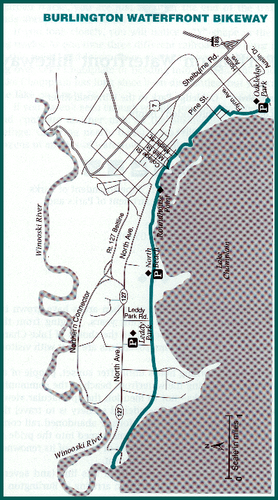
A map of the Burlington Waterfront Bikeway copied from the Rails-to-Trails Conservancy Web Site.
 Chittendon
County Transit Authority (CCTA) buses provide
public transportation on the North Avenue (N) and Lakeside (L) routes
that roughly parallels the entire length of the Bikeway. Details of this bus
service are noted on the individual pages of this Web Site. These two routes connect
with all of the other bus
routes that serve other parts of the city and surrounding suburbs at the Cherry Street
Station in downtown Burlington. In addition, many other bus routes stop at one or
more places on Battery Street near the downtown section of the rail-trail. Note that all CCTA vehicles
feature bike racks.
Chittendon
County Transit Authority (CCTA) buses provide
public transportation on the North Avenue (N) and Lakeside (L) routes
that roughly parallels the entire length of the Bikeway. Details of this bus
service are noted on the individual pages of this Web Site. These two routes connect
with all of the other bus
routes that serve other parts of the city and surrounding suburbs at the Cherry Street
Station in downtown Burlington. In addition, many other bus routes stop at one or
more places on Battery Street near the downtown section of the rail-trail. Note that all CCTA vehicles
feature bike racks.
 Amtrak's
Vermonter stops at Essex Jct. (ESX) on a daily
basis. Note that the Vermonter features a
baggage car with bike racks (available by reservation only). Amtrak
schedules are also available at the DVARP
Web Site in
the traditional format. The (CCTA)
Essex (E) route can be used as a connecting bus to the Cherry Street terminal in
downtown Burlington as well as a stop near the rail-trail at College and Battery Streets.
Amtrak's
Vermonter stops at Essex Jct. (ESX) on a daily
basis. Note that the Vermonter features a
baggage car with bike racks (available by reservation only). Amtrak
schedules are also available at the DVARP
Web Site in
the traditional format. The (CCTA)
Essex (E) route can be used as a connecting bus to the Cherry Street terminal in
downtown Burlington as well as a stop near the rail-trail at College and Battery Streets.
 Lake Champlain
Transportation Company operates an automobile
ferry on a seasonal basis from a ferry dock at King Street (adjacent to the downtown section of the
Rail-trail) to Port Kent NY. This ferry connects
to Amtrak's
Adirondack at the adjacent Port Kent Station (PRK).
Note that the Adirondack
also features a baggage car with bike
racks (available by reservation only).
Lake Champlain
Transportation Company operates an automobile
ferry on a seasonal basis from a ferry dock at King Street (adjacent to the downtown section of the
Rail-trail) to Port Kent NY. This ferry connects
to Amtrak's
Adirondack at the adjacent Port Kent Station (PRK).
Note that the Adirondack
also features a baggage car with bike
racks (available by reservation only).
 Vermont Transit (Greyhound)
serves a terminal on Pine Street in Burlington (#1986 & #1987) with
intercity bus service to most parts of Vermont as well as
Montreal, Boston, and Albany. Greyhound and other carriers offer
connections to a multitude of other points across the Continental
USA. Note that Vermont Transit accepts bikes in boxes as part of
the passenger baggage allowance. The (CCTA)
Lakeside (L) bus can be used as
a connecting bus to the Cherry Street Station in
downtown Burlington as well as a stop near the rail-trail at College and Battery Streets.
Vermont Transit (Greyhound)
serves a terminal on Pine Street in Burlington (#1986 & #1987) with
intercity bus service to most parts of Vermont as well as
Montreal, Boston, and Albany. Greyhound and other carriers offer
connections to a multitude of other points across the Continental
USA. Note that Vermont Transit accepts bikes in boxes as part of
the passenger baggage allowance. The (CCTA)
Lakeside (L) bus can be used as
a connecting bus to the Cherry Street Station in
downtown Burlington as well as a stop near the rail-trail at College and Battery Streets.
Books about the trail:
A 7.5 mile section of the Trail within Burlington from Oakledge Park to the Winooski River is described in section 27 of the Official Rails-to-Trails Conservancy New England Guidebook by Cynthia Mascott published in 2000 by Globe Pequot Press. This trail listing contains a photograph, historical description, trail head directions and parking, a trail map, trail details, a local trail manager contact, and much more.
This trail is described in Great Rail Trails of the Northeast by Craig Della Penna. The information includes a historical background of the trail as well as a detailed description keyed to bicycle odometer readings from the author's in person trip down the trail. This book is out of print but copies may still exist in some bookstores.
| Project Name | Year | City | County | Federal $ | Local $ | Total $ |
|---|---|---|---|---|---|---|
| Pedestrian Access to Waterfront | 1994 | Burlington | N/A | $38,000 | $9,500 | $47,500 |
This list is drawn on April 16, 2000 from a database maintained by the National Transportation Enhancements Clearinghouse. Direct questions to NTEC at 1-888-388-NTEC or by email to [email protected].
| Item | From | To | Year | RR | Miles |
|---|---|---|---|---|---|
| 251 | Burlington | Rouses Point, NY | 1963 | RUT | 40 |
