


|
|
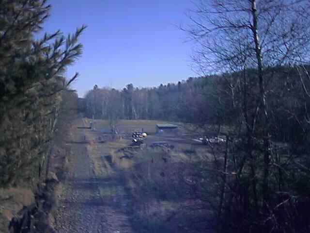
Looking East at Andover Station from Lawrence Road Overpass. Digital Picture by Kenyon F. Karl on December 19, 1999.
The location of this station was confirmed by the remains of the asphalt station platform.
Trail access is available at the following points:
Switch Road Crossing about 1.7 miles east of Andover Station.
South Short Street about a mile east of Andover Station (leading to Rte 4 south of the railroad underpass).
Andover Station (Lawrence Road)
Bridge Street Crossing about 0.8 miles west of Andover Station.
Note that a tiny but modern building located at the Switch Road crossing about 1.7 miles east of Andover Station. This building contains electronic equipment for the fibre optics cable and is is identical to the building at Canaan Station.
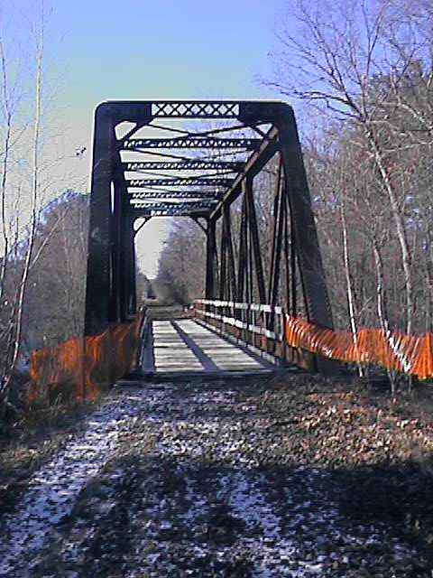
A truss bridge a short distance east of Andover Station. Digital Picture by Kenyon F. Karl on December 19, 1999.
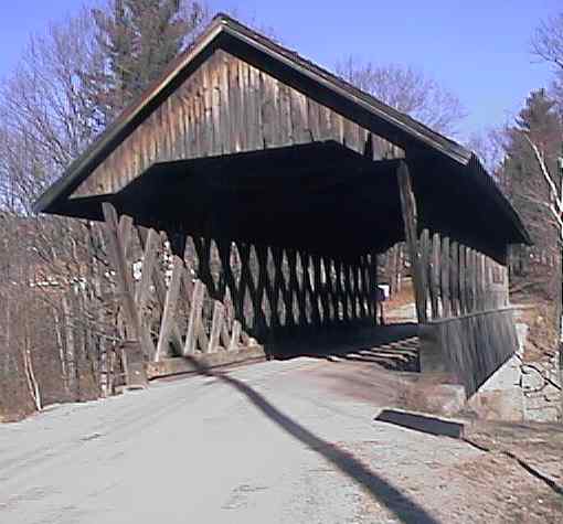
The Keniston Bridge at Bridge Road. Digital Picture by Kenyon F. Karl on December 19, 1999.


 A small parking area is adjacent to the station site, although it may be full
during games in the adjacent baseball field. The Chemical Toilet was not
spotted on December 19, 1999 thus it may be present only during baseball season.
A new foundation for the playground equipment was apparently under construction
on December 19, 1999. The baseball dugouts ought to provide emergency shelter during
inclement weather.
A small parking area is adjacent to the station site, although it may be full
during games in the adjacent baseball field. The Chemical Toilet was not
spotted on December 19, 1999 thus it may be present only during baseball season.
A new foundation for the playground equipment was apparently under construction
on December 19, 1999. The baseball dugouts ought to provide emergency shelter during
inclement weather.


 A convenience store with gasoline, and a post office are located at the intersection of Route 4
and Lawrence Road, about 0.2 miles north of Andover Station via Lawrence Rd. A sign at the door
to the convenience store indicates that there are no public toilets available
inside.
A convenience store with gasoline, and a post office are located at the intersection of Route 4
and Lawrence Road, about 0.2 miles north of Andover Station via Lawrence Rd. A sign at the door
to the convenience store indicates that there are no public toilets available
inside.

 A
pizza parlor is located on Route 4 a short distance east of Lawrence Road.
Toilets and water are presumably available upon request.
A
pizza parlor is located on Route 4 a short distance east of Lawrence Road.
Toilets and water are presumably available upon request.
 A Bike
& Ski shop
is located
on Route 4 a short distance west of Lawrence Road.
A Bike
& Ski shop
is located
on Route 4 a short distance west of Lawrence Road.
 One or two Bed
& Breakfasts were noted in the vicinity of Proctor Academy.
One or two Bed
& Breakfasts were noted in the vicinity of Proctor Academy.
 Proctor Academy is
located on Route 4 a short distance west of Lawrence Road.
Proctor Academy is
located on Route 4 a short distance west of Lawrence Road.
 The Sunapee Ragged Kearsarge Greenway
(SRKG) will eventually cross the Northern Line Rail Trail on the Lawrence Street
overpass at
Andover Station. It will also turn a corner adjacent to the
Bridge Road crossing. For more information about the trail,
please contact:
The Sunapee Ragged Kearsarge Greenway
(SRKG) will eventually cross the Northern Line Rail Trail on the Lawrence Street
overpass at
Andover Station. It will also turn a corner adjacent to the
Bridge Road crossing. For more information about the trail,
please contact:
The Keniston Covered Bridge (#15) is adjacent to the Northern Line Rail-trail at the Bridge
Street Crossing.
Any Mapblast Map on this Web Site is a link to the Mapblast Web Site which in turn leads to a Business Directory of the surrounding area.
Sign images are from the Manual of Traffic Signs by Richard C. Moeur.
Updated on February 14, 2001 by Kenyon F.
Karl <[email protected]>.
Unintentional errors are likely!
