


|
|
![]() USGS
Topographic map of Randolph
USGS
Topographic map of Randolph
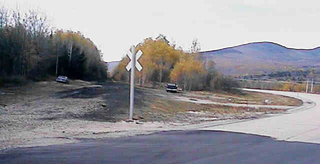
Looking west across site of Randolph Station. Digital photograph by Kenyon F. Karl on October 23, 1997.
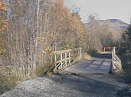
Looking east across Bumpus Brook Bridge. Digital photograph by Kenyon F. Karl on October 23, 1997.
The Randolph Mountain Club Web Site has pictures of the valley and the surrounding mountains in its photo gallery. Note that many of the hiking trails that begin in the Randolph Valley are maintained by the Randolph Mountain Club. The club also maintains cabins and shelters high in the mountains immediately south of the Rail-trail. Additional hiking trails leave from Durand Road (parallels the Rail-trail, a short distance north of Route 2), to climb Randolph Hill.
 The former
station location is apparently usable as a moderate sized parking
area.
The former
station location is apparently usable as a moderate sized parking
area.
No other trail facilities are observable at this location.
The Pinkham B
Road which crosses at the site of the Depot is a lightly used
road through a pass near Pine Mountain to the extensive Dolly
Copp Campground and also Route 16. Note that this steep and
narrow road is gravel surfaced in some areas and is not plowed in
the winter. Although it is not formally designated as a bike
route, this lightly used road should be reasonably safe for
biking and equestrian purposes. Because this road is not plowed in winter
(beyond
the nearby farm houses), it should also be useful for adventurous x-c-skiers and
snowmobilers!
 The Town
Line Brook Trail to Triple Falls forms a 0.4 mile (round
trip) steep nature trail with 200 foot elevation gain that passes
three scenic waterfalls. The trailhead is marked with a sign on
the Pinkham B Road, 1.4 miles southeast of the Rail-trail
crossing at Randolph Depot. Complete information about this trail
is provided in the book Nature Walks in the White Mountains by
Robert N. Buchsbaum, published as a Nature Walks Book by the Appalachian Mountain Club.
Complete information about this trail is also provided in the AMC
White Mountain Guide published by the Appalachian Mountain Club.
The Town
Line Brook Trail to Triple Falls forms a 0.4 mile (round
trip) steep nature trail with 200 foot elevation gain that passes
three scenic waterfalls. The trailhead is marked with a sign on
the Pinkham B Road, 1.4 miles southeast of the Rail-trail
crossing at Randolph Depot. Complete information about this trail
is provided in the book Nature Walks in the White Mountains by
Robert N. Buchsbaum, published as a Nature Walks Book by the Appalachian Mountain Club.
Complete information about this trail is also provided in the AMC
White Mountain Guide published by the Appalachian Mountain Club.
The Pine
Mountain Trail forms a 3.5 mile (round trip) nature
trail with 750 foot elevation gain which is rated as moderate for
kids. The trailhead is a gated gravel road adjacent to a trail
sign across from a small trail parking area on the Pinkham B Road,
southeast of the Rail-trail crossing at Randolph Depot (measured
as 3 miles from nearby Route 2). A very long beginning and the
entire return trip uses the privately maintained access road to
the Horton Center, which is shown on the Mapblast Maps and the
DeLorme Atlas as a minor gravel road. However, this road is
signed as being open to the public for foot travel only. Complete
information about this trail is provided in the book Nature
Walks in the White Mountains by Robert N. Buchsbaum,
published as a Nature Walks Book by the Appalachian Mountain Club.
Complete information about this trail is also provided in the AMC
White Mountain Guide published by the Appalachian Mountain Club.
Kelton Trail and
Howker Ridge Trail begin at the small gravel parking lot on
Pinkham B Road and cross the Rail-trail shortly thereafter, about
0.3 mile west of Randolph Depot. Complete information about these
trails is provided in the AMC White Mountain Guide
published by the Appalachian
Mountain Club. This parking lot may be controlled by the White Mountain
National Forest and hence its usage may be subject to the recreation fee.
No other public facilities are observable at this trailhead.
Sign images are from the Manual of Traffic Signs by Richard C. Moeur.
Updated on February 28, 2001 by Kenyon F.
Karl <[email protected]>.
Unintentional errors are likely!
